Porthcawl geodata
Porthcawl (Wales) is a populated place; located in United Kingdom in Europe/London (GMT+0) time zone. With population of 15,672 people, there are 741 cities with bigger population in this country. Compared to other cities in United Kingdom, 78.5% of cities are located further ↑North; 84.7% of cities are located further →East and 89.9% of cities have higher elevation than Porthcawl. Note1


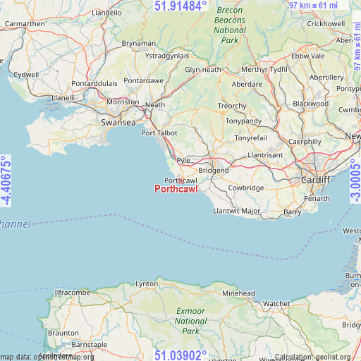
Porthcawl GPS coordinates[2]
51° 28' 44.508" North, 3° 42' 13.032" West
| Map corner | latitude | longitude |
|---|---|---|
| Upper-left | 51.91484°, | -4.40675° |
| Center: | 51.47903°, | -3.70362° |
| Lower-right: | 51.03902°, | -3.0005° |
| Map W x H: | 97.4×97.4 km | = 60.5×60.5mi |
| max Lat: | 60.39635° ⇑78.5% North |
| Porthcawl: | 51.47903° |
| min Lat: | ⇓21.5% South 34.60088° |
| min Long | Porthcawl | max Long |
| -7.64133° | -3.70362° | 32.95536° |
| W 15.3%⇐ | ⇒84.7% E |
Elevation
Elevation of Porthcawl is 12 m = 39 ft, and this is 60.9 m = 200 ft below average elevation for this country.
| Max E: |
515 m = 1690 ft | 89.9% |
| Avg. | 72.9 m = 239 ft | |
| Porthcawl | 12 m = 39 ft | |
Min E: |
-30 m = -98 ft | 10.1% |
See also: United Kingdom elevation on elevation.city.
Geographical zone
Porthcawl is located in North temperate zone (between Tropic of Cancer and the Arctic Circle). Distance of this North polar circle is 1677.2 km =1042.2 mi to North.| Distance of | km | miles | from Porthcawl |
|---|---|---|---|
| North Pole | 4283.1 | 2661.4 | to North |
| Arctic Circle | 1677.2 | 1042.2 | to North |
| Tropic Cancer | 3118 | 1937.4 | to South |
| Equator | 5723.9 | 3556.7 | to South |


Nearby cities:
15 places around Porthcawl: (largest is in red/bold)
• Aberkenfig
10.1 km =6.3 mi,  47°
47°
• Betws
12.8 km =8 mi,  38°
38°
• Bridgend
9.2 km =5.7 mi,  71°
71°
• Cefn Cribwr
6.8 km =4.2 mi,  31°
31°
• Coity
11.3 km =7 mi, 65°
• Ewenny
9 km =5.6 mi,  88°
88°
• Llangan
14.1 km =8.8 mi, 86°
• Llangeinor
14.2 km =8.8 mi, 40°
• Merthyr Mawr
6.6 km =4.1 mi,  83°
83°
• Ogmore-by-Sea
5.5 km =3.4 mi,  112°
112°
• Pont Rhyd-y-cyff
12.9 km =8 mi,  21°
21°
• Port Talbot
13.7 km =8.5 mi,  337°
337°
• Pyle
4.2 km =2.6 mi,  3°
3°
• Taibach
12.4 km =7.7 mi, 339°
• Wick
11.6 km =7.2 mi, 112°
Sources, notices
• [Note1] Compared only with cities in United Kingdom existing in our database
• [Src1] Map data: © OpenStreetMap contributors (CC-BY-SA)
• [Src2] Other city data from geonames.org with taken over terms of usage.
• [Src3] Geographical zone / Annual Mean Temperature by Robert A. Rohde @ Wikipedia
