Porlock geodata
Porlock (England) is a populated place; located in United Kingdom in Europe/London (GMT+1) time zone. With population of 1,213 people, there are 3338 cities with bigger population in this country. Compared to other cities in United Kingdom, 86.6% of cities are located further ↑North; 83.6% of cities are located further →East and 68.3% of cities have higher elevation than Porlock. Note1
Administrative division(s):
- Level 1: England
- Level 2: Somerset
- Level 3: West Somerset District
- Level 4: Porlock


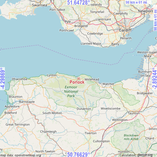
Porlock GPS coordinates[2]
51° 12' 32.004" North, 3° 35' 44.016" West
| Map corner | latitude | longitude |
|---|---|---|
| Upper-left | 51.64728°, | -4.29869° |
| Center: | 51.20889°, | -3.59556° |
| Lower-right: | 50.76629°, | -2.89244° |
| Map W x H: | 98×98 km | = 60.9×60.9mi |
| max Lat: | 60.39635° ⇑86.6% North |
| Porlock: | 51.20889° |
| min Lat: | ⇓13.4% South 34.60088° |
| min Long | Porlock | max Long |
| -7.64133° | -3.59556° | 32.95536° |
| W 16.4%⇐ | ⇒83.6% E |
Elevation
Elevation of Porlock is 35 m = 115 ft, and this is 37.9 m = 124 ft below average elevation for this country.
| Max E: |
515 m = 1690 ft | 68.3% |
| Avg. | 72.9 m = 239 ft | |
| Porlock | 35 m = 115 ft | |
Min E: |
-30 m = -98 ft | 31.7% |
See also: United Kingdom elevation on elevation.city.
Geographical zone
Porlock is located in North temperate zone (between Tropic of Cancer and the Arctic Circle). Distance of this North polar circle is 1707.3 km =1060.9 mi to North.| Distance of | km | miles | from Porlock |
|---|---|---|---|
| North Pole | 4313.2 | 2680.1 | to North |
| Arctic Circle | 1707.3 | 1060.9 | to North |
| Tropic Cancer | 3088 | 1918.8 | to South |
| Equator | 5693.9 | 3538 | to South |


Nearby cities:
15 places around Porlock: (largest is in red/bold)
• Bratton Fleming
25.8 km =16 mi,  248°
248°
• Carhampton
12.7 km =7.9 mi,  107°
107°
• Dulverton
19 km =11.8 mi,  170°
170°
• Llantwit Major
23.7 km =14.7 mi,  18°
18°
• Lynton
17.3 km =10.7 mi,  277°
277°
• Minehead
7.9 km =4.9 mi,  93°
93°
• North Molton
22.3 km =13.9 mi,  219°
219°
• Ogmore-by-Sea
28.1 km =17.5 mi,  355°
355°
• Rhoose
26.1 km =16.2 mi,  40°
40°
• South Molton
27.1 km =16.8 mi, 217°
• Washford
17.1 km =10.6 mi, 108°
• Watchet
18.7 km =11.6 mi,  99°
99°
• Wick
25.8 km =16 mi,  7°
7°
• Williton
19.7 km =12.2 mi, 105°
• Wiveliscombe
27.1 km =16.8 mi,  133°
133°
Sources, notices
• [Note1] Compared only with cities in United Kingdom existing in our database
• [Src1] Map data: © OpenStreetMap contributors (CC-BY-SA)
• [Src2] Other city data from geonames.org with taken over terms of usage.
• [Src3] Geographical zone / Annual Mean Temperature by Robert A. Rohde @ Wikipedia
