Washford geodata
Washford (England) is a populated place; located in United Kingdom in Europe/London (GMT+1) time zone. With population of 601 people, there are 4570 cities with bigger population in this country. Compared to other cities in United Kingdom, 87.7% of cities are located further ↑North; 80.3% of cities are located further →East and 62.4% of cities have higher elevation than Washford. Note1
Administrative division(s):
- Level 1: England
- Level 2: Somerset
- Level 3: West Somerset District
- Level 4: Old Cleeve


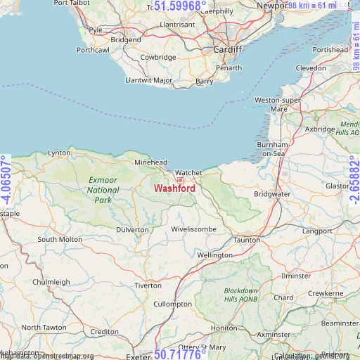
Washford GPS coordinates[2]
51° 9' 38.988" North, 3° 21' 42.984" West
| Map corner | latitude | longitude |
|---|---|---|
| Upper-left | 51.59968°, | -4.06507° |
| Center: | 51.16083°, | -3.36194° |
| Lower-right: | 50.71776°, | -2.65882° |
| Map W x H: | 98.1×98.1 km | = 61×61mi |
| max Lat: | 60.39635° ⇑87.7% North |
| Washford: | 51.16083° |
| min Lat: | ⇓12.3% South 34.60088° |
| min Long | Washford | max Long |
| -7.64133° | -3.36194° | 32.95536° |
| W 19.7%⇐ | ⇒80.3% E |
Elevation
Elevation of Washford is 43 m = 141 ft, and this is 29.9 m = 98 ft below average elevation for this country.
| Max E: |
515 m = 1690 ft | 62.4% |
| Avg. | 72.9 m = 239 ft | |
| Washford | 43 m = 141 ft | |
Min E: |
-30 m = -98 ft | 37.6% |
See also: United Kingdom elevation on elevation.city.
Geographical zone
Washford is located in North temperate zone (between Tropic of Cancer and the Arctic Circle). Distance of this North polar circle is 1712.6 km =1064.2 mi to North.| Distance of | km | miles | from Washford |
|---|---|---|---|
| North Pole | 4318.5 | 2683.4 | to North |
| Arctic Circle | 1712.6 | 1064.2 | to North |
| Tropic Cancer | 3082.6 | 1915.4 | to South |
| Equator | 5688.6 | 3534.7 | to South |


Nearby cities:
15 places around Washford: (largest is in red/bold)
• Bishops Lydeard
16.6 km =10.3 mi,  132°
132°
• Carhampton
4.4 km =2.7 mi,  290°
290°
• Dulverton
18.8 km =11.7 mi,  224°
224°
• Langford Budville
19.3 km =12 mi,  160°
160°
• Milverton
17.1 km =10.6 mi,  153°
153°
• Minehead
9.7 km =6 mi,  299°
299°
• Nether Stowey
14.4 km =8.9 mi,  94°
94°
• Pawlett
25.2 km =15.7 mi, 85°
• Porlock
17.1 km =10.6 mi, 288°
• Rhoose
25.3 km =15.7 mi,  1°
1°
• Stogursey
15.5 km =9.6 mi,  82°
82°
• Taunton
24.3 km =15.1 mi, 131°
• Watchet
3.2 km =2 mi,  42°
42°
• Williton
2.8 km =1.7 mi, 86°
• Wiveliscombe
13.7 km =8.5 mi,  165°
165°
Sources, notices
• [Note1] Compared only with cities in United Kingdom existing in our database
• [Src1] Map data: © OpenStreetMap contributors (CC-BY-SA)
• [Src2] Other city data from geonames.org with taken over terms of usage.
• [Src3] Geographical zone / Annual Mean Temperature by Robert A. Rohde @ Wikipedia
