Dulverton geodata
Dulverton (England) is a populated place; located in United Kingdom in Europe/London (GMT+1) time zone. With population of 1,052 people, there are 3561 cities with bigger population in this country. Compared to other cities in United Kingdom, 90.4% of cities are located further ↑North; 83% of cities are located further →East and 88.3% of cities have lower elevation than Dulverton. Note1
Administrative division(s):
- Level 1: England
- Level 2: Somerset
- Level 3: West Somerset District
- Level 4: Dulverton


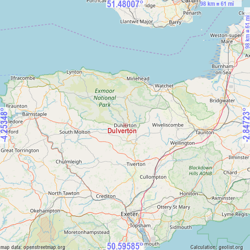
Dulverton GPS coordinates[2]
51° 2' 24.252" North, 3° 33' 1.26" West
| Map corner | latitude | longitude |
|---|---|---|
| Upper-left | 51.48007°, | -4.25348° |
| Center: | 51.04007°, | -3.55035° |
| Lower-right: | 50.59585°, | -2.84723° |
| Map W x H: | 98.3×98.3 km | = 61.1×61.1mi |
| max Lat: | 60.39635° ⇑90.4% North |
| Dulverton: | 51.04007° |
| min Lat: | ⇓9.6% South 34.60088° |
| min Long | Dulverton | max Long |
| -7.64133° | -3.55035° | 32.95536° |
| W 17%⇐ | ⇒83% E |
Elevation
Elevation of Dulverton is 144 m = 472 ft, and this is 71.1 m = 233 ft above average elevation for this country.
| Max E: |
515 m = 1690 ft | 11.7% |
| Dulverton | 144 m 472 ft | |
| Avg. | 72.9 m = 239 ft | |
Min E: |
-30 m = -98 ft | 88.3% |
See also: United Kingdom elevation on elevation.city.
Geographical zone
Dulverton is located in North temperate zone (between Tropic of Cancer and the Arctic Circle). Distance of this North polar circle is 1726.1 km =1072.5 mi to North.| Distance of | km | miles | from Dulverton |
|---|---|---|---|
| North Pole | 4331.9 | 2691.7 | to North |
| Arctic Circle | 1726.1 | 1072.5 | to North |
| Tropic Cancer | 3069.2 | 1907.1 | to South |
| Equator | 5675.1 | 3526.3 | to South |


Nearby cities:
15 places around Dulverton: (largest is in red/bold)
• Bickleigh
20.6 km =12.8 mi,  171°
171°
• Carhampton
17.5 km =10.9 mi,  31°
31°
• Halberton
17.6 km =10.9 mi,  146°
146°
• Langford Budville
20.3 km =12.6 mi,  103°
103°
• Milverton
20.9 km =13 mi, 95°
• Minehead
18.9 km =11.7 mi,  14°
14°
• North Molton
17.5 km =10.9 mi,  275°
275°
• Porlock
19 km =11.8 mi,  350°
350°
• Sampford Peverell
17.9 km =11.1 mi,  138°
138°
• South Molton
20 km =12.4 mi,  262°
262°
• Tiverton
15.8 km =9.8 mi, 165°
• Washford
18.8 km =11.7 mi,  44°
44°
• Williton
21 km =13 mi,  49°
49°
• Witheridge
17.3 km =10.7 mi,  218°
218°
• Wiveliscombe
16.6 km =10.3 mi,  89°
89°
Sources, notices
• [Note1] Compared only with cities in United Kingdom existing in our database
• [Src1] Map data: © OpenStreetMap contributors (CC-BY-SA)
• [Src2] Other city data from geonames.org with taken over terms of usage.
• [Src3] Geographical zone / Annual Mean Temperature by Robert A. Rohde @ Wikipedia
