Minehead geodata
Minehead (England) is a populated place; located in United Kingdom in Europe/London (GMT+1) time zone. With population of 11,981 people, there are 914 cities with bigger population in this country. Compared to other cities in United Kingdom, 86.7% of cities are located further ↑North; 82% of cities are located further →East and 73.1% of cities have higher elevation than Minehead. Note1
Administrative division(s):
- Level 1: England
- Level 2: Somerset
- Level 3: West Somerset District
- Level 4: Minehead


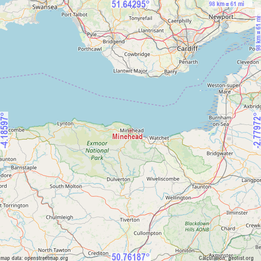
Minehead GPS coordinates[2]
51° 12' 16.272" North, 3° 28' 58.224" West
| Map corner | latitude | longitude |
|---|---|---|
| Upper-left | 51.64295°, | -4.18597° |
| Center: | 51.20452°, | -3.48284° |
| Lower-right: | 50.76187°, | -2.77972° |
| Map W x H: | 98×98 km | = 60.9×60.9mi |
| max Lat: | 60.39635° ⇑86.7% North |
| Minehead: | 51.20452° |
| min Lat: | ⇓13.3% South 34.60088° |
| min Long | Minehead | max Long |
| -7.64133° | -3.48284° | 32.95536° |
| W 18%⇐ | ⇒82% E |
Elevation
Elevation of Minehead is 29 m = 95 ft, and this is 43.9 m = 144 ft below average elevation for this country.
| Max E: |
515 m = 1690 ft | 73.1% |
| Avg. | 72.9 m = 239 ft | |
| Minehead | 29 m = 95 ft | |
Min E: |
-30 m = -98 ft | 26.9% |
See also: United Kingdom elevation on elevation.city.
Geographical zone
Minehead is located in North temperate zone (between Tropic of Cancer and the Arctic Circle). Distance of this North polar circle is 1707.8 km =1061.2 mi to North.| Distance of | km | miles | from Minehead |
|---|---|---|---|
| North Pole | 4313.7 | 2680.4 | to North |
| Arctic Circle | 1707.8 | 1061.2 | to North |
| Tropic Cancer | 3087.5 | 1918.5 | to South |
| Equator | 5693.4 | 3537.7 | to South |


Nearby cities:
15 places around Minehead: (largest is in red/bold)
• Barry
25.7 km =16 mi,  32°
32°
• Bishops Lydeard
26.2 km =16.3 mi,  128°
128°
• Carhampton
5.4 km =3.4 mi, 127°
• Dulverton
18.9 km =11.7 mi,  194°
194°
• Llantwit Major
22.9 km =14.2 mi,  359°
359°
• Lynton
25.1 km =15.6 mi,  276°
276°
• Milverton
25.8 km =16 mi,  141°
141°
• Nether Stowey
23.5 km =14.6 mi,  104°
104°
• Porlock
7.9 km =4.9 mi,  273°
273°
• Rhoose
22.3 km =13.9 mi,  23°
23°
• Stogursey
23.9 km =14.9 mi, 96°
• Washford
9.7 km =6 mi,  119°
119°
• Watchet
10.9 km =6.8 mi, 103°
• Williton
12.1 km =7.5 mi,  112°
112°
• Wiveliscombe
21.7 km =13.5 mi,  146°
146°
Sources, notices
• [Note1] Compared only with cities in United Kingdom existing in our database
• [Src1] Map data: © OpenStreetMap contributors (CC-BY-SA)
• [Src2] Other city data from geonames.org with taken over terms of usage.
• [Src3] Geographical zone / Annual Mean Temperature by Robert A. Rohde @ Wikipedia
