Polzeath geodata
Polzeath (England) is a populated place; located in United Kingdom in Europe/London (GMT+1) time zone. With population of 1,449 people, there are 3091 cities with bigger population in this country. Compared to other cities in United Kingdom, 97.6% of cities are located further ↑North; 95.8% of cities are located further →East and 53.7% of cities have higher elevation than Polzeath. Note1


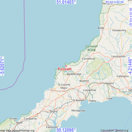
Polzeath GPS coordinates[2]
50° 34' 10.416" North, 4° 55' 3.324" West
| Map corner | latitude | longitude |
|---|---|---|
| Upper-left | 51.01403°, | -5.62071° |
| Center: | 50.56956°, | -4.91759° |
| Lower-right: | 50.12086°, | -4.21446° |
| Map W x H: | 99.3×99.3 km | = 61.7×61.7mi |
| max Lat: | 60.39635° ⇑97.6% North |
| Polzeath: | 50.56956° |
| min Lat: | ⇓2.4% South 34.60088° |
| min Long | Polzeath | max Long |
| -7.64133° | -4.91759° | 32.95536° |
| W 4.2%⇐ | ⇒95.8% E |
Elevation
Elevation of Polzeath is 55 m = 180 ft, and this is 17.9 m = 59 ft below average elevation for this country.
| Max E: |
515 m = 1690 ft | 53.7% |
| Avg. | 72.9 m = 239 ft | |
| Polzeath | 55 m = 180 ft | |
Min E: |
-30 m = -98 ft | 46.3% |
See also: United Kingdom elevation on elevation.city.
Geographical zone
Polzeath is located in North temperate zone (between Tropic of Cancer and the Arctic Circle). Distance of this North polar circle is 1778.4 km =1105 mi to North.| Distance of | km | miles | from Polzeath |
|---|---|---|---|
| North Pole | 4384.3 | 2724.3 | to North |
| Arctic Circle | 1778.4 | 1105 | to North |
| Tropic Cancer | 3016.9 | 1874.6 | to South |
| Equator | 5622.8 | 3493.8 | to South |


Nearby cities:
15 places around Polzeath: (largest is in red/bold)
• Bodmin
17.5 km =10.9 mi,  128°
128°
• Boscastle
20.3 km =12.6 mi,  51°
51°
• Bugle
21.2 km =13.2 mi,  155°
155°
• Camelford
17.8 km =11.1 mi,  70°
70°
• Delabole
14.4 km =8.9 mi, 65°
• Helland
16.2 km =10.1 mi,  118°
118°
• Lanivet
17.7 km =11 mi,  142°
142°
• Newquay
20.4 km =12.7 mi,  212°
212°
• Padstow
3.7 km =2.3 mi,  201°
201°
• Roche
18.9 km =11.7 mi, 161°
• Rock
2.4 km =1.5 mi, 157°
• Saint Columb Major
15.4 km =9.6 mi,  186°
186°
• Saint Dennis
20.8 km =12.9 mi,  173°
173°
• Tintagel
15.7 km =9.8 mi, 48°
• Wadebridge
8.2 km =5.1 mi, 135°
Sources, notices
• [Note1] Compared only with cities in United Kingdom existing in our database
• [Src1] Map data: © OpenStreetMap contributors (CC-BY-SA)
• [Src2] Other city data from geonames.org with taken over terms of usage.
• [Src3] Geographical zone / Annual Mean Temperature by Robert A. Rohde @ Wikipedia
