Newtyle geodata
Newtyle (Scotland) is a populated place; located in United Kingdom in Europe/London (GMT+1) time zone. With population of 730 people, there are 4194 cities with bigger population in this country. Compared to other cities in United Kingdom, 96.8% of cities are located further ↓South; 77.6% of cities are located further →East and 66.5% of cities have lower elevation than Newtyle. Note1


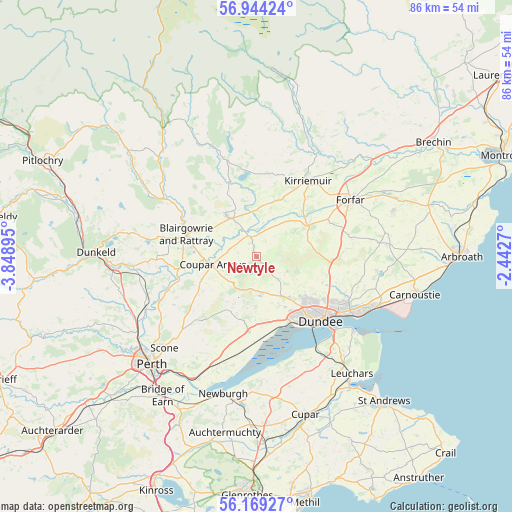
Newtyle GPS coordinates[2]
56° 33' 31.464" North, 3° 8' 44.988" West
| Map corner | latitude | longitude |
|---|---|---|
| Upper-left | 56.94424°, | -3.84895° |
| Center: | 56.55874°, | -3.14583° |
| Lower-right: | 56.16927°, | -2.4427° |
| Map W x H: | 86.2×86.2 km | = 53.6×53.6mi |
| max Lat: | 60.39635° ⇑3.2% North |
| Newtyle: | 56.55874° |
| min Lat: | ⇓96.8% South 34.60088° |
| min Long | Newtyle | max Long |
| -7.64133° | -3.14583° | 32.95536° |
| W 22.4%⇐ | ⇒77.6% E |
Elevation
Elevation of Newtyle is 89 m = 292 ft, and this is 16.1 m = 53 ft above average elevation for this country.
| Max E: |
515 m = 1690 ft | 33.5% |
| Newtyle | 89 m 292 ft | |
| Avg. | 72.9 m = 239 ft | |
Min E: |
-30 m = -98 ft | 66.5% |
See also: United Kingdom elevation on elevation.city.
Geographical zone
Newtyle is located in North temperate zone (between Tropic of Cancer and the Arctic Circle). Distance of this North polar circle is 1112.4 km =691.2 mi to North.| Distance of | km | miles | from Newtyle |
|---|---|---|---|
| North Pole | 3718.3 | 2310.4 | to North |
| Arctic Circle | 1112.4 | 691.2 | to North |
| Tropic Cancer | 3682.8 | 2288.4 | to South |
| Equator | 6288.7 | 3907.6 | to South |


Nearby cities:
15 places around Newtyle: (largest is in red/bold)
• Alyth
8.7 km =5.4 mi,  323°
323°
• Blairgowrie
12.5 km =7.8 mi,  287°
287°
• Burrelton
10.4 km =6.5 mi,  246°
246°
• Coupar Angus
7.6 km =4.7 mi,  258°
258°
• Dundee
14.5 km =9 mi,  133°
133°
• Forfar
18.3 km =11.4 mi,  58°
58°
• Gauldry
19 km =11.8 mi,  154°
154°
• Inchture
12.7 km =7.9 mi,  186°
186°
• Invergowrie
12 km =7.5 mi, 154°
• Kirriemuir
15.5 km =9.6 mi,  34°
34°
• Liff
8.9 km =5.5 mi,  155°
155°
• Longforgan
11.4 km =7.1 mi,  170°
170°
• Muirhead
8.1 km =5 mi,  143°
143°
• Newport-on-Tay
18.5 km =11.5 mi, 136°
• Wellbank
17.9 km =11.1 mi,  102°
102°
Sources, notices
• [Note1] Compared only with cities in United Kingdom existing in our database
• [Src1] Map data: © OpenStreetMap contributors (CC-BY-SA)
• [Src2] Other city data from geonames.org with taken over terms of usage.
• [Src3] Geographical zone / Annual Mean Temperature by Robert A. Rohde @ Wikipedia
