Morden geodata
Morden (England) is a seat of a third-order administrative division; located in United Kingdom in Europe/London (GMT+1) time zone. With population of 48,233 people, there are 244 cities with bigger population in this country. Compared to other cities in United Kingdom, 81% of cities are located further ↑North; 82.9% of cities are located further ←West and 79% of cities have higher elevation than Morden. Note1


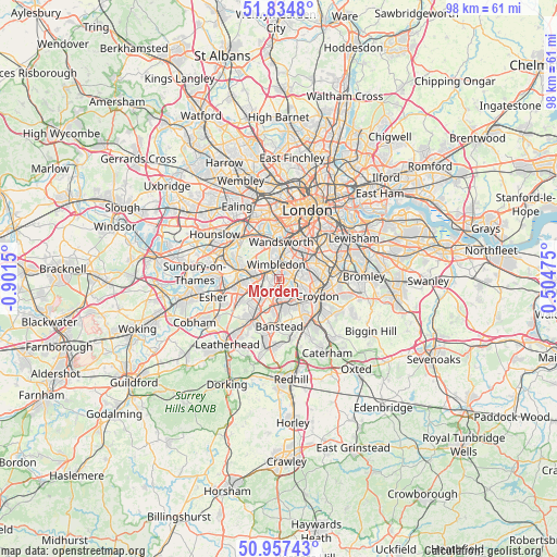
Morden GPS coordinates[2]
51° 23' 53.592" North, 0° 11' 54.132" West
| Map corner | latitude | longitude |
|---|---|---|
| Upper-left | 51.8348°, | -0.9015° |
| Center: | 51.39822°, | -0.19837° |
| Lower-right: | 50.95743°, | 0.50475° |
| Map W x H: | 97.6×97.6 km | = 60.6×60.6mi |
| max Lat: | 60.39635° ⇑81% North |
| Morden: | 51.39822° |
| min Lat: | ⇓19% South 34.60088° |
| min Long | Morden | max Long |
| -7.64133° | -0.19837° | 32.95536° |
| W 82.9%⇐ | ⇒17.1% E |
Elevation
Elevation of Morden is 22 m = 72 ft, and this is 50.9 m = 167 ft below average elevation for this country.
| Max E: |
515 m = 1690 ft | 79% |
| Avg. | 72.9 m = 239 ft | |
| Morden | 22 m = 72 ft | |
Min E: |
-30 m = -98 ft | 21% |
See also: Morden elevation on elevation.city.
Geographical zone
Morden is located in North temperate zone (between Tropic of Cancer and the Arctic Circle). Distance of this North polar circle is 1686.2 km =1047.8 mi to North.| Distance of | km | miles | from Morden |
|---|---|---|---|
| North Pole | 4292.1 | 2667 | to North |
| Arctic Circle | 1686.2 | 1047.8 | to North |
| Tropic Cancer | 3109 | 1931.8 | to South |
| Equator | 5714.9 | 3551.1 | to South |


Nearby cities:
15 places around Morden: (largest is in red/bold)
• Brixton Hill
8 km =5 mi,  41°
41°
• Carshalton
4 km =2.5 mi,  147°
147°
• Cheam
4.3 km =2.7 mi,  200°
200°
• Croydon
7 km =4.3 mi,  103°
103°
• Earlsfield
5.2 km =3.2 mi,  10°
10°
• Ewell
6.5 km =4 mi,  213°
213°
• Hook
8.2 km =5.1 mi,  245°
245°
• Kingston upon Thames
7.1 km =4.4 mi,  283°
283°
• Mitcham
2.2 km =1.4 mi,  75°
75°
• New Malden
4.4 km =2.7 mi,  273°
273°
• Surbiton
7 km =4.3 mi,  263°
263°
• Sutton
5.4 km =3.4 mi,  181°
181°
• Thornton Heath
6.9 km =4.3 mi,  89°
89°
• Wandsworth
6.6 km =4.1 mi,  354°
354°
• Worcester Park
3.8 km =2.4 mi,  237°
237°
Sources, notices
• [Note1] Compared only with cities in United Kingdom existing in our database
• [Src1] Map data: © OpenStreetMap contributors (CC-BY-SA)
• [Src2] Other city data from geonames.org with taken over terms of usage.
• [Src3] Geographical zone / Annual Mean Temperature by Robert A. Rohde @ Wikipedia
