Sutton geodata
Sutton (England) is a seat of a third-order administrative division; located in United Kingdom in Europe/London (GMT+1) time zone. With population of 187,600 people, there are 42 cities with bigger population in this country. Compared to other cities in United Kingdom, 82.6% of cities are located further ↑North; 82.9% of cities are located further ←West and 63.6% of cities have lower elevation than Sutton. Note1


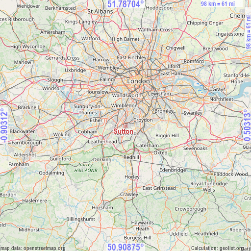
Sutton GPS coordinates[2]
51° 21' 0" North, 0° 12' 0" West
| Map corner | latitude | longitude |
|---|---|---|
| Upper-left | 51.78704°, | -0.90312° |
| Center: | 51.35°, | -0.2° |
| Lower-right: | 50.90875°, | 0.50313° |
| Map W x H: | 97.7×97.7 km | = 60.7×60.7mi |
| max Lat: | 60.39635° ⇑82.6% North |
| Sutton: | 51.35° |
| min Lat: | ⇓17.4% South 34.60088° |
| min Long | Sutton | max Long |
| -7.64133° | -0.2° | 32.95536° |
| W 82.9%⇐ | ⇒17.1% E |
Elevation
Elevation of Sutton is 83 m = 272 ft, and this is 10.1 m = 33 ft above average elevation for this country.
| Max E: |
515 m = 1690 ft | 36.4% |
| Sutton | 83 m 272 ft | |
| Avg. | 72.9 m = 239 ft | |
Min E: |
-30 m = -98 ft | 63.6% |
See also: Sutton elevation on elevation.city.
Geographical zone
Sutton is located in North temperate zone (between Tropic of Cancer and the Arctic Circle). Distance of this North polar circle is 1691.6 km =1051.1 mi to North.| Distance of | km | miles | from Sutton |
|---|---|---|---|
| North Pole | 4297.5 | 2670.3 | to North |
| Arctic Circle | 1691.6 | 1051.1 | to North |
| Tropic Cancer | 3103.7 | 1928.5 | to South |
| Equator | 5709.6 | 3547.8 | to South |


Nearby cities:
15 places around Sutton: (largest is in red/bold)
• Banstead
3.1 km =1.9 mi,  188°
188°
• Carshalton
3 km =1.9 mi,  47°
47°
• Cheam
1.9 km =1.2 mi,  313°
313°
• Chessington
7.4 km =4.6 mi,  280°
280°
• Coulsdon
5.3 km =3.3 mi,  129°
129°
• Epsom
5.3 km =3.3 mi,  245°
245°
• Ewell
3.4 km =2.1 mi,  269°
269°
• Hook
7.7 km =4.8 mi,  285°
285°
• Mitcham
6.3 km =3.9 mi,  20°
20°
• Morden
5.4 km =3.4 mi,  1°
1°
• New Malden
7.1 km =4.4 mi,  322°
322°
• Purley
6.3 km =3.9 mi,  103°
103°
• South Croydon
7.5 km =4.7 mi,  79°
79°
• Tadworth
6.9 km =4.3 mi,  201°
201°
• Worcester Park
4.5 km =2.8 mi, 317°
Sources, notices
• [Note1] Compared only with cities in United Kingdom existing in our database
• [Src1] Map data: © OpenStreetMap contributors (CC-BY-SA)
• [Src2] Other city data from geonames.org with taken over terms of usage.
• [Src3] Geographical zone / Annual Mean Temperature by Robert A. Rohde @ Wikipedia
