Carshalton geodata
Carshalton (England) is a populated place; located in United Kingdom in Europe/London (GMT+0) time zone. With population of 45,525 people, there are 263 cities with bigger population in this country. Compared to other cities in United Kingdom, 82% of cities are located further ↑North; 83.6% of cities are located further ←West and 65.5% of cities have higher elevation than Carshalton. Note1


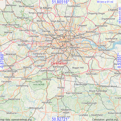
Carshalton GPS coordinates[2]
51° 22' 5.844" North, 0° 10' 3.18" West
| Map corner | latitude | longitude |
|---|---|---|
| Upper-left | 51.80516°, | -0.87068° |
| Center: | 51.36829°, | -0.16755° |
| Lower-right: | 50.92721°, | 0.53557° |
| Map W x H: | 97.6×97.6 km | = 60.6×60.6mi |
| max Lat: | 60.39635° ⇑82% North |
| Carshalton: | 51.36829° |
| min Lat: | ⇓18% South 34.60088° |
| min Long | Carshalton | max Long |
| -7.64133° | -0.16755° | 32.95536° |
| W 83.6%⇐ | ⇒16.4% E |
Elevation
Elevation of Carshalton is 39 m = 128 ft, and this is 33.9 m = 111 ft below average elevation for this country.
| Max E: |
515 m = 1690 ft | 65.5% |
| Avg. | 72.9 m = 239 ft | |
| Carshalton | 39 m = 128 ft | |
Min E: |
-30 m = -98 ft | 34.5% |
See also: Carshalton elevation on elevation.city.
Geographical zone
Carshalton is located in North temperate zone (between Tropic of Cancer and the Arctic Circle). Distance of this North polar circle is 1689.6 km =1049.9 mi to North.| Distance of | km | miles | from Carshalton |
|---|---|---|---|
| North Pole | 4295.4 | 2669 | to North |
| Arctic Circle | 1689.6 | 1049.9 | to North |
| Tropic Cancer | 3105.7 | 1929.8 | to South |
| Equator | 5711.6 | 3549 | to South |


Nearby cities:
15 places around Carshalton: (largest is in red/bold)
• Banstead
5.8 km =3.6 mi,  208°
208°
• Cheam
3.7 km =2.3 mi,  258°
258°
• Coulsdon
5.7 km =3.5 mi,  160°
160°
• Croydon
5 km =3.1 mi,  70°
70°
• Earlsfield
8.5 km =5.3 mi,  351°
351°
• Epsom
8.3 km =5.2 mi,  239°
239°
• Ewell
6.1 km =3.8 mi,  249°
249°
• Mitcham
3.9 km =2.4 mi,  359°
359°
• Morden
4 km =2.5 mi,  327°
327°
• New Malden
7.5 km =4.7 mi,  298°
298°
• Purley
5.2 km =3.2 mi,  132°
132°
• South Croydon
5.1 km =3.2 mi,  97°
97°
• Sutton
3 km =1.9 mi,  227°
227°
• Thornton Heath
5.9 km =3.7 mi,  54°
54°
• Worcester Park
5.5 km =3.4 mi,  283°
283°
Sources, notices
• [Note1] Compared only with cities in United Kingdom existing in our database
• [Src1] Map data: © OpenStreetMap contributors (CC-BY-SA)
• [Src2] Other city data from geonames.org with taken over terms of usage.
• [Src3] Geographical zone / Annual Mean Temperature by Robert A. Rohde @ Wikipedia
