Mitcham geodata
Mitcham (England) is a populated place; located in United Kingdom in Europe/London (GMT+1) time zone. With population of 48,311 people, there are 243 cities with bigger population in this country. Compared to other cities in United Kingdom, 80.7% of cities are located further ↑North; 83.6% of cities are located further ←West and 79% of cities have higher elevation than Mitcham. Note1


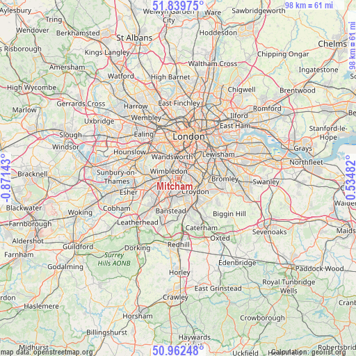
Mitcham GPS coordinates[2]
51° 24' 11.592" North, 0° 10' 5.916" West
| Map corner | latitude | longitude |
|---|---|---|
| Upper-left | 51.83975°, | -0.87143° |
| Center: | 51.40322°, | -0.16831° |
| Lower-right: | 50.96248°, | 0.53482° |
| Map W x H: | 97.5×97.5 km | = 60.6×60.6mi |
| max Lat: | 60.39635° ⇑80.7% North |
| Mitcham: | 51.40322° |
| min Lat: | ⇓19.3% South 34.60088° |
| min Long | Mitcham | max Long |
| -7.64133° | -0.16831° | 32.95536° |
| W 83.6%⇐ | ⇒16.4% E |
Elevation
Elevation of Mitcham is 22 m = 72 ft, and this is 50.9 m = 167 ft below average elevation for this country.
| Max E: |
515 m = 1690 ft | 79% |
| Avg. | 72.9 m = 239 ft | |
| Mitcham | 22 m = 72 ft | |
Min E: |
-30 m = -98 ft | 21% |
See also: Mitcham elevation on elevation.city.
Geographical zone
Mitcham is located in North temperate zone (between Tropic of Cancer and the Arctic Circle). Distance of this North polar circle is 1685.7 km =1047.4 mi to North.| Distance of | km | miles | from Mitcham |
|---|---|---|---|
| North Pole | 4291.6 | 2666.7 | to North |
| Arctic Circle | 1685.7 | 1047.4 | to North |
| Tropic Cancer | 3109.6 | 1932.2 | to South |
| Equator | 5715.5 | 3551.4 | to South |


Nearby cities:
15 places around Mitcham: (largest is in red/bold)
• Battersea
8 km =5 mi,  6°
6°
• Brixton
8.2 km =5.1 mi,  31°
31°
• Brixton Hill
6.3 km =3.9 mi, 30°
• Carshalton
3.9 km =2.4 mi,  179°
179°
• Cheam
5.8 km =3.6 mi,  217°
217°
• Croydon
5.2 km =3.2 mi,  115°
115°
• Earlsfield
4.7 km =2.9 mi,  345°
345°
• Ewell
8.2 km =5.1 mi, 223°
• Morden
2.2 km =1.4 mi,  255°
255°
• New Malden
6.5 km =4 mi,  267°
267°
• South Croydon
6.9 km =4.3 mi,  131°
131°
• Sutton
6.3 km =3.9 mi,  200°
200°
• Thornton Heath
4.9 km =3 mi,  95°
95°
• Wandsworth
6.6 km =4.1 mi,  335°
335°
• Worcester Park
5.9 km =3.7 mi,  243°
243°
Sources, notices
• [Note1] Compared only with cities in United Kingdom existing in our database
• [Src1] Map data: © OpenStreetMap contributors (CC-BY-SA)
• [Src2] Other city data from geonames.org with taken over terms of usage.
• [Src3] Geographical zone / Annual Mean Temperature by Robert A. Rohde @ Wikipedia
