Bentworth geodata
Bentworth (England) is a populated place; located in United Kingdom in Europe/London (GMT+1) time zone. With population of 553 people, there are 4725 cities with bigger population in this country. Compared to other cities in United Kingdom, 87.8% of cities are located further ↑North; 65.7% of cities are located further ←West and 94.5% of cities have lower elevation than Bentworth. Note1
Administrative division(s):
- Level 1: England
- Level 2: Hampshire
- Level 3: East Hampshire District
- Level 4: Bentworth


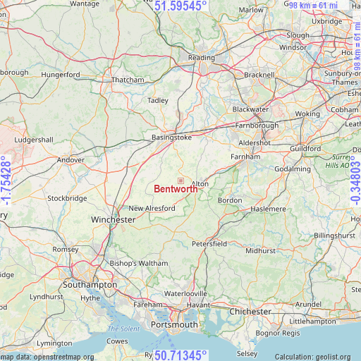
Bentworth GPS coordinates[2]
51° 9' 23.616" North, 1° 3' 4.14" West
| Map corner | latitude | longitude |
|---|---|---|
| Upper-left | 51.59545°, | -1.75428° |
| Center: | 51.15656°, | -1.05115° |
| Lower-right: | 50.71345°, | -0.34803° |
| Map W x H: | 98.1×98.1 km | = 61×61mi |
| max Lat: | 60.39635° ⇑87.8% North |
| Bentworth: | 51.15656° |
| min Lat: | ⇓12.2% South 34.60088° |
| min Long | Bentworth | max Long |
| -7.64133° | -1.05115° | 32.95536° |
| W 65.7%⇐ | ⇒34.3% E |
Elevation
Elevation of Bentworth is 179 m = 587 ft, and this is 106.1 m = 348 ft above average elevation for this country.
| Max E: |
515 m = 1690 ft | 5.5% |
| Bentworth | 179 m 587 ft | |
| Avg. | 72.9 m = 239 ft | |
Min E: |
-30 m = -98 ft | 94.5% |
See also: United Kingdom elevation on elevation.city.
Geographical zone
Bentworth is located in North temperate zone (between Tropic of Cancer and the Arctic Circle). Distance of this North polar circle is 1713.1 km =1064.5 mi to North.| Distance of | km | miles | from Bentworth |
|---|---|---|---|
| North Pole | 4319 | 2683.7 | to North |
| Arctic Circle | 1713.1 | 1064.5 | to North |
| Tropic Cancer | 3082.2 | 1915.2 | to South |
| Equator | 5688.1 | 3534.4 | to South |


Nearby cities:
15 places around Bentworth: (largest is in red/bold)
• Alton
5.4 km =3.4 mi,  98°
98°
• Basingstoke
12 km =7.5 mi,  348°
348°
• Bordon
14 km =8.7 mi,  109°
109°
• Crondall
15.6 km =9.7 mi,  57°
57°
• Four Marks
5.5 km =3.4 mi,  178°
178°
• Hook
15.6 km =9.7 mi,  24°
24°
• Kingsley
12.2 km =7.6 mi, 99°
• Lindford
14.9 km =9.3 mi, 106°
• Long Sutton
10.3 km =6.4 mi,  47°
47°
• New Alresford
11.4 km =7.1 mi,  226°
226°
• North Waltham
11.9 km =7.4 mi,  301°
301°
• Odiham
13.4 km =8.3 mi,  35°
35°
• Old Basing
12.3 km =7.6 mi,  5°
5°
• Preston Candover
6 km =3.7 mi,  285°
285°
• Selborne
10.4 km =6.5 mi,  131°
131°
Sources, notices
• [Note1] Compared only with cities in United Kingdom existing in our database
• [Src1] Map data: © OpenStreetMap contributors (CC-BY-SA)
• [Src2] Other city data from geonames.org with taken over terms of usage.
• [Src3] Geographical zone / Annual Mean Temperature by Robert A. Rohde @ Wikipedia
