Forfar geodata
Forfar (Scotland) is a seat of a second-order administrative division; located in United Kingdom in Europe/London (GMT+1) time zone. With population of 13,970 people, there are 818 cities with bigger population in this country. Compared to other cities in United Kingdom, 97% of cities are located further ↓South; 72.9% of cities are located further →East and 51.8% of cities have lower elevation than Forfar. Note1


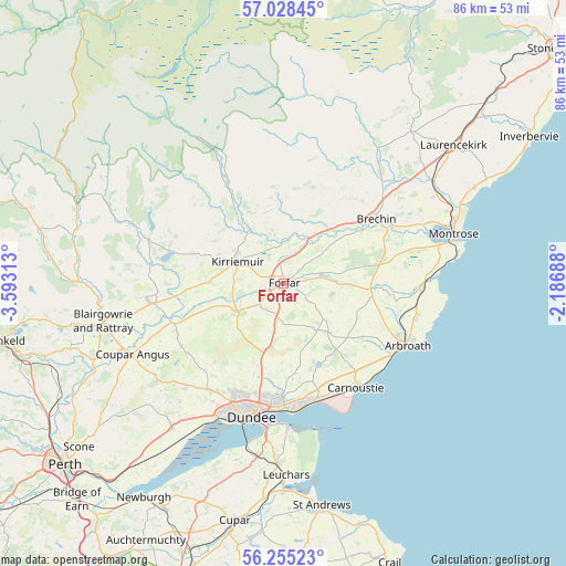
Forfar GPS coordinates[2]
56° 38' 37.752" North, 2° 53' 24.036" West
| Map corner | latitude | longitude |
|---|---|---|
| Upper-left | 57.02845°, | -3.59313° |
| Center: | 56.64382°, | -2.89001° |
| Lower-right: | 56.25523°, | -2.18688° |
| Map W x H: | 86×86 km | = 53.4×53.4mi |
| max Lat: | 60.39635° ⇑3% North |
| Forfar: | 56.64382° |
| min Lat: | ⇓97% South 34.60088° |
| min Long | Forfar | max Long |
| -7.64133° | -2.89001° | 32.95536° |
| W 27.1%⇐ | ⇒72.9% E |
Elevation
Elevation of Forfar is 63 m = 207 ft, and this is 9.9 m = 32 ft below average elevation for this country.
| Max E: |
515 m = 1690 ft | 48.2% |
| Avg. | 72.9 m = 239 ft | |
| Forfar | 63 m = 207 ft | |
Min E: |
-30 m = -98 ft | 51.8% |
See also: United Kingdom elevation on elevation.city.
Geographical zone
Forfar is located in North temperate zone (between Tropic of Cancer and the Arctic Circle). Distance of this North polar circle is 1103 km =685.4 mi to North.| Distance of | km | miles | from Forfar |
|---|---|---|---|
| North Pole | 3708.9 | 2304.6 | to North |
| Arctic Circle | 1103 | 685.4 | to North |
| Tropic Cancer | 3692.3 | 2294.3 | to South |
| Equator | 6298.2 | 3913.5 | to South |


Nearby cities:
15 places around Forfar: (largest is in red/bold)
• Alyth
20.9 km =13 mi,  263°
263°
• Arbroath
20.6 km =12.8 mi,  115°
115°
• Brechin
17.1 km =10.6 mi,  56°
56°
• Carnoustie
19.4 km =12.1 mi,  144°
144°
• Dundee
20.1 km =12.5 mi,  194°
194°
• Friockheim
13.6 km =8.5 mi,  93°
93°
• Kirriemuir
7.7 km =4.8 mi,  295°
295°
• Letham
7.5 km =4.7 mi,  104°
104°
• Liff
21.3 km =13.2 mi,  214°
214°
• Monifieth
18.5 km =11.5 mi,  166°
166°
• Muirhead
19.3 km =12 mi, 214°
• Newport-on-Tay
22.9 km =14.2 mi, 187°
• Newtyle
18.3 km =11.4 mi,  238°
238°
• Tayport
21.9 km =13.6 mi,  178°
178°
• Wellbank
13.4 km =8.3 mi, 172°
Sources, notices
• [Note1] Compared only with cities in United Kingdom existing in our database
• [Src1] Map data: © OpenStreetMap contributors (CC-BY-SA)
• [Src2] Other city data from geonames.org with taken over terms of usage.
• [Src3] Geographical zone / Annual Mean Temperature by Robert A. Rohde @ Wikipedia
