Bowmore geodata
Bowmore (Scotland) is a populated place; located in United Kingdom in Europe/London (GMT+1) time zone. With population of 760 people, there are 4115 cities with bigger population in this country. Compared to other cities in United Kingdom, 90.4% of cities are located further ↓South; 98.9% of cities are located further →East and 80.8% of cities have higher elevation than Bowmore. Note1


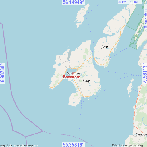
Bowmore GPS coordinates[2]
55° 45' 20.988" North, 6° 17' 3.336" West
| Map corner | latitude | longitude |
|---|---|---|
| Upper-left | 56.14949°, | -6.98738° |
| Center: | 55.75583°, | -6.28426° |
| Lower-right: | 55.35816°, | -5.58113° |
| Map W x H: | 88×88 km | = 54.7×54.7mi |
| max Lat: | 60.39635° ⇑9.6% North |
| Bowmore: | 55.75583° |
| min Lat: | ⇓90.4% South 34.60088° |
| min Long | Bowmore | max Long |
| -7.64133° | -6.28426° | 32.95536° |
| W 1.1%⇐ | ⇒98.9% E |
Elevation
Elevation of Bowmore is 20 m = 66 ft, and this is 52.9 m = 174 ft below average elevation for this country.
| Max E: |
515 m = 1690 ft | 80.8% |
| Avg. | 72.9 m = 239 ft | |
| Bowmore | 20 m = 66 ft | |
Min E: |
-30 m = -98 ft | 19.2% |
See also: United Kingdom elevation on elevation.city.
Geographical zone
Bowmore is located in North temperate zone (between Tropic of Cancer and the Arctic Circle). Distance of this North polar circle is 1201.7 km =746.7 mi to North.| Distance of | km | miles | from Bowmore |
|---|---|---|---|
| North Pole | 3807.6 | 2365.9 | to North |
| Arctic Circle | 1201.7 | 746.7 | to North |
| Tropic Cancer | 3593.5 | 2232.9 | to South |
| Equator | 6199.5 | 3852.2 | to South |


Nearby cities:
15 places around Bowmore: (largest is in red/bold)
• Ardrishaig
59.6 km =37 mi,  61°
61°
• Ballintoy Harbour
57.1 km =35.5 mi,  185°
185°
• Ballycastle
61.4 km =38.2 mi,  177°
177°
• Ballypatrick
64.5 km =40.1 mi,  172°
172°
• Bushmills
63 km =39.1 mi, 193°
• Campbeltown
56.2 km =34.9 mi,  130°
130°
• Coleraine
73.3 km =45.5 mi,  199°
199°
• Isle of Arran
70 km =43.5 mi,  106°
106°
• Isle of Islay
4.3 km =2.7 mi,  40°
40°
• Lochgilphead
61.7 km =38.3 mi, 59°
• Port Ellen
15 km =9.3 mi,  155°
155°
• Portrush
66.4 km =41.3 mi, 200°
• Portstewart
69.4 km =43.1 mi, 202°
• Tarbert
55.5 km =34.5 mi,  77°
77°
• Tighnabruaich
67.7 km =42.1 mi, 75°
Sources, notices
• [Note1] Compared only with cities in United Kingdom existing in our database
• [Src1] Map data: © OpenStreetMap contributors (CC-BY-SA)
• [Src2] Other city data from geonames.org with taken over terms of usage.
• [Src3] Geographical zone / Annual Mean Temperature by Robert A. Rohde @ Wikipedia
