Betws-y-Coed geodata
Betws-y-Coed (Wales) is a seat of a third-order administrative division; located in United Kingdom in Europe/London (GMT+1) time zone. With population of 1,200 people, there are 3354 cities with bigger population in this country. Compared to other cities in United Kingdom, 62% of cities are located further ↓South; 85.9% of cities are located further →East and 72.3% of cities have higher elevation than Betws-y-Coed. Note1


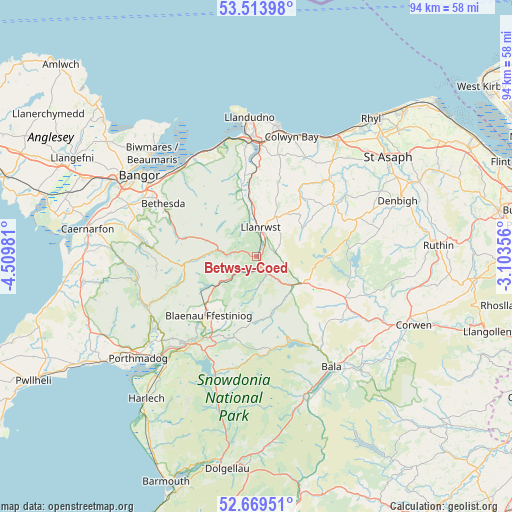
Betws-y-Coed GPS coordinates[2]
53° 5' 37.752" North, 3° 48' 24.048" West
| Map corner | latitude | longitude |
|---|---|---|
| Upper-left | 53.51398°, | -4.50981° |
| Center: | 53.09382°, | -3.80668° |
| Lower-right: | 52.66951°, | -3.10356° |
| Map W x H: | 93.9×93.9 km | = 58.3×58.3mi |
| max Lat: | 60.39635° ⇑38% North |
| Betws-y-Coed: | 53.09382° |
| min Lat: | ⇓62% South 34.60088° |
| min Long | Betws-y-Coed | max Long |
| -7.64133° | -3.80668° | 32.95536° |
| W 14.1%⇐ | ⇒85.9% E |
Elevation
Elevation of Betws-y-Coed is 30 m = 98 ft, and this is 42.9 m = 141 ft below average elevation for this country.
| Max E: |
515 m = 1690 ft | 72.3% |
| Avg. | 72.9 m = 239 ft | |
| Betws-y-Coed | 30 m = 98 ft | |
Min E: |
-30 m = -98 ft | 27.7% |
See also: United Kingdom elevation on elevation.city.
Geographical zone
Betws-y-Coed is located in North temperate zone (between Tropic of Cancer and the Arctic Circle). Distance of this North polar circle is 1497.7 km =930.6 mi to North.| Distance of | km | miles | from Betws-y-Coed |
|---|---|---|---|
| North Pole | 4103.6 | 2549.9 | to North |
| Arctic Circle | 1497.7 | 930.6 | to North |
| Tropic Cancer | 3297.6 | 2049 | to South |
| Equator | 5903.5 | 3668.3 | to South |


Nearby cities:
15 places around Betws-y-Coed: (largest is in red/bold)
• Aber
20.9 km =13 mi,  317°
317°
• Bethesda
19.4 km =12.1 mi,  300°
300°
• Blaenau-Ffestiniog
14.1 km =8.8 mi,  218°
218°
• Conwy
20.8 km =12.9 mi,  355°
355°
• Ffestiniog
17.1 km =10.6 mi,  209°
209°
• Llan Ffestiniog
17.3 km =10.7 mi, 208°
• Llanberis
21.7 km =13.5 mi,  277°
277°
• Llanfairfechan
21.4 km =13.3 mi,  328°
328°
• Llanrwst
5.2 km =3.2 mi,  8°
8°
• Llansantffraid Glan Conwy
19.2 km =11.9 mi,  1°
1°
• Maentwrog
20.4 km =12.7 mi, 216°
• Mochdre
21.4 km =13.3 mi, 10°
• Penmaenmawr
21 km =13 mi,  336°
336°
• Trefriw
6.5 km =4 mi,  348°
348°
• Tregarth
21.6 km =13.4 mi, 299°
Sources, notices
• [Note1] Compared only with cities in United Kingdom existing in our database
• [Src1] Map data: © OpenStreetMap contributors (CC-BY-SA)
• [Src2] Other city data from geonames.org with taken over terms of usage.
• [Src3] Geographical zone / Annual Mean Temperature by Robert A. Rohde @ Wikipedia
