Purley geodata
Purley (England) is a populated place; located in United Kingdom in Europe/London (GMT+1) time zone. With population of 72,000 people, there are 145 cities with bigger population in this country. Compared to other cities in United Kingdom, 83.1% of cities are located further ↑North; 84.7% of cities are located further ←West and 70.7% of cities have lower elevation than Purley. Note1


Purley GPS coordinates[2]
51° 20' 12.408" North, 0° 6' 43.236" West
| Map corner | latitude | longitude |
|---|---|---|
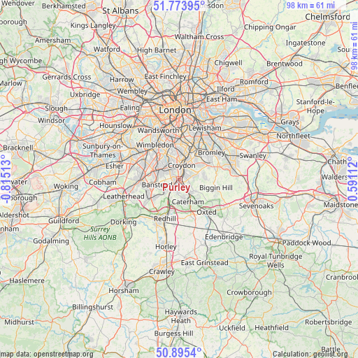
| Upper-left | 51.77395°, | -0.81513° |
| Center: | 51.33678°, | -0.11201° |
| Lower-right: | 50.8954°, | 0.59112° |
| Map W x H: | 97.7×97.7 km | = 60.7×60.7mi |
| max Lat: | 60.39635° ⇑83.1% North |
| Purley: | 51.33678° |
| min Lat: | ⇓16.9% South 34.60088° |
| min Long | Purley | max Long |
| -7.64133° | -0.11201° | 32.95536° |
| W 84.7%⇐ | ⇒15.3% E |
Elevation
Elevation of Purley is 97 m = 318 ft, and this is 24.1 m = 79 ft above average elevation for this country.
| Max E: |
515 m = 1690 ft | 29.3% |
| Purley | 97 m 318 ft | |
| Avg. | 72.9 m = 239 ft | |
Min E: |
-30 m = -98 ft | 70.7% |
See also: Purley elevation on elevation.city.
Geographical zone
Purley is located in North temperate zone (between Tropic of Cancer and the Arctic Circle). Distance of this North polar circle is 1693.1 km =1052 mi to North.| Distance of | km | miles | from Purley |
|---|---|---|---|
| North Pole | 4298.9 | 2671.2 | to North |
| Arctic Circle | 1693.1 | 1052 | to North |
| Tropic Cancer | 3102.2 | 1927.6 | to South |
| Equator | 5708.1 | 3546.8 | to South |


Nearby cities:
15 places around Purley: (largest is in red/bold)
• Banstead
6.8 km =4.2 mi,  256°
256°
• Carshalton
5.2 km =3.2 mi,  312°
312°
• Caterham
6.5 km =4 mi,  159°
159°
• Cheam
8 km =5 mi,  290°
290°
• Coulsdon
2.7 km =1.7 mi,  227°
227°
• Croydon
5.2 km =3.2 mi,  9°
9°
• Mitcham
8.4 km =5.2 mi,  332°
332°
• Morden
9.1 km =5.7 mi,  318°
318°
• South Croydon
3.1 km =1.9 mi,  23°
23°
• Sutton
6.3 km =3.9 mi,  283°
283°
• Thornton Heath
7 km =4.3 mi, 7°
• Warlingham
4.8 km =3 mi,  128°
128°
• West Wickham
7.4 km =4.6 mi,  63°
63°
• Whyteleafe
3.7 km =2.3 mi,  148°
148°
• Woldingham
7.9 km =4.9 mi,  136°
136°
Sources, notices
• [Note1] Compared only with cities in United Kingdom existing in our database
• [Src1] Map data: © OpenStreetMap contributors (CC-BY-SA)
• [Src2] Other city data from geonames.org with taken over terms of usage.
• [Src3] Geographical zone / Annual Mean Temperature by Robert A. Rohde @ Wikipedia
