Isles of Scilly geodata
Isles of Scilly (England) is a populated locality; located in United Kingdom in Europe/London (GMT+1) time zone. With population of 2,100 people, there are 2566 cities with bigger population in this country. Compared to other cities in United Kingdom, 99.9% of cities are located further ↑North; 98.9% of cities are located further →East and 64% of cities have higher elevation than Isles of Scilly. Note1


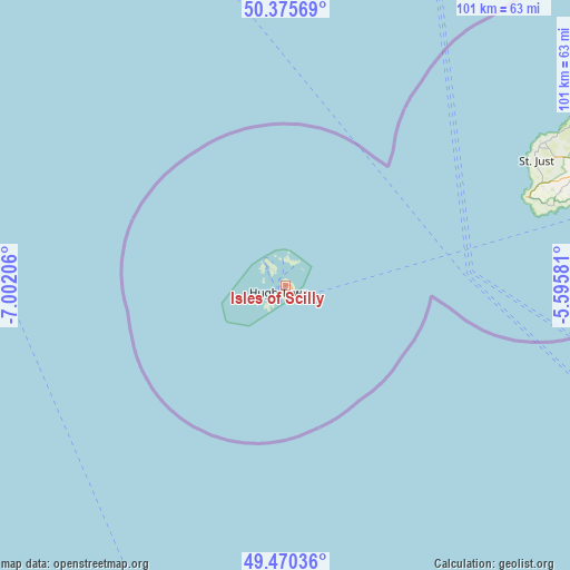
Isles of Scilly GPS coordinates[2]
49° 55' 30.54" North, 6° 17' 56.184" West
| Map corner | latitude | longitude |
|---|---|---|
| Upper-left | 50.37569°, | -7.00206° |
| Center: | 49.92515°, | -6.29894° |
| Lower-right: | 49.47036°, | -5.59581° |
| Map W x H: | 100.7×100.7 km | = 62.6×62.6mi |
| max Lat: | 60.39635° ⇑99.9% North |
| Isles of Scilly: | 49.92515° |
| min Lat: | ⇓0.1% South 34.60088° |
| min Long | Isles of Scilly | max Long |
| -7.64133° | -6.29894° | 32.95536° |
| W 1.1%⇐ | ⇒98.9% E |
Elevation
Elevation of Isles of Scilly is 41 m = 135 ft, and this is 31.9 m = 105 ft below average elevation for this country.
| Max E: |
515 m = 1690 ft | 64% |
| Avg. | 72.9 m = 239 ft | |
| Isles of Scilly | 41 m = 135 ft | |
Min E: |
-30 m = -98 ft | 36% |
See also: United Kingdom elevation on elevation.city.
Geographical zone
Isles of Scilly is located in North temperate zone (between Tropic of Cancer and the Arctic Circle). Distance of this North polar circle is 1850 km =1149.5 mi to North.| Distance of | km | miles | from Isles of Scilly |
|---|---|---|---|
| North Pole | 4455.9 | 2768.8 | to North |
| Arctic Circle | 1850 | 1149.5 | to North |
| Tropic Cancer | 2945.2 | 1830.1 | to South |
| Equator | 5551.2 | 3449.4 | to South |


Nearby cities:
15 places around Isles of Scilly: (largest is in red/bold)
• Germoe
69.1 km =42.9 mi,  72°
72°
• Hayle
68.9 km =42.8 mi, 65°
• Helston
76.1 km =47.3 mi, 74°
• Hugh Town
1.5 km =0.9 mi,  217°
217°
• Madron
57.3 km =35.6 mi, 66°
• Marazion
62.9 km =39.1 mi, 69°
• Mousehole
57.1 km =35.5 mi, 72°
• Penzance
58.5 km =36.4 mi, 68°
• Porthleven
72.6 km =45.1 mi,  75°
75°
• Sennen
46 km =28.6 mi, 68°
• St Ives
65.9 km =40.9 mi,  61°
61°
• St Just
49.4 km =30.7 mi, 63°
• St Mary's
0.9 km =0.6 mi,  163°
163°
• St. Buryan
51.1 km =31.8 mi, 71°
• Uny Lelant
67.7 km =42.1 mi, 64°
Sources, notices
• [Note1] Compared only with cities in United Kingdom existing in our database
• [Src1] Map data: © OpenStreetMap contributors (CC-BY-SA)
• [Src2] Other city data from geonames.org with taken over terms of usage.
• [Src3] Geographical zone / Annual Mean Temperature by Robert A. Rohde @ Wikipedia
