Saba geodata
Saba (North Bank) is a populated place; located in Gambia in Africa/Banjul (GMT+0) time zone. With population of 1,974 people, there are 29 cities with bigger population in this country. Compared to other cities in Gambia, 68.3% of cities are located further ↓South; 86.2% of cities are located further →East and 70.7% of cities have higher elevation than Saba. Note1


Saba GPS coordinates[2]
13° 30' 59.004" North, 16° 2' 57.012" West
| Map corner | latitude | longitude |
|---|---|---|
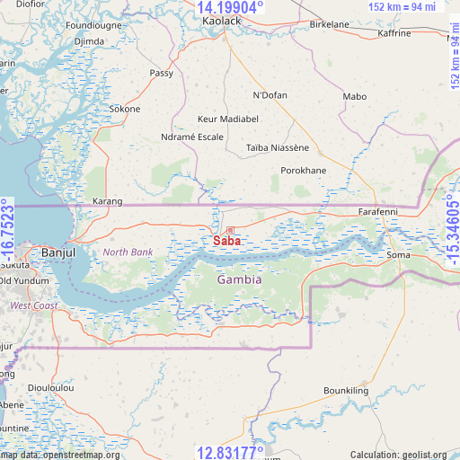
| Upper-left | 14.19904°, | -16.7523° |
| Center: | 13.51639°, | -16.04917° |
| Lower-right: | 12.83177°, | -15.34605° |
| Map W x H: | 152×152 km | = 94.4×94.4mi |
| max Lat: | 13.8° ⇑31.7% North |
| Saba: | 13.51639° |
| min Lat: | ⇓68.3% South 13.20194° |
| min Long | Saba | max Long |
| -16.73389° | -16.04917° | -13.85° |
| W 13.8%⇐ | ⇒86.2% E |
Elevation
Elevation of Saba is 15 m = 49 ft, and this is 6.1 m = 20 ft below average elevation for this country.
| Max E: |
49 m = 161 ft | 70.7% |
| Avg. | 21.1 m = 69 ft | |
| Saba | 15 m = 49 ft | |
Min E: |
1 m = 3 ft | 29.3% |
See also: Gambia elevation on elevation.city.
Geographical zone
Saba is located in North Torrid zone (between Equator and Tropic of Cancer). Distance of this Northern Tropic circle is 1103 km =685.4 mi to North.| Distance of | km | miles | from Saba |
|---|---|---|---|
| North Pole | 8504.2 | 5284.3 | to North |
| Arctic Circle | 5898.3 | 3665 | to North |
| Tropic Cancer | 1103 | 685.4 | to North |
| Equator | 1502.9 | 933.9 | to South |


Nearby cities:
15 places around Saba: (largest is in red/bold)
• Bajana
28.5 km =17.7 mi,  141°
141°
• Chilla
25.6 km =15.9 mi,  278°
278°
• Daru Rilwan
8 km =5 mi,  62°
62°
• Dobo
9.7 km =6 mi,  67°
67°
• Gunjur
2.4 km =1.5 mi, 72°
• Jali
20.5 km =12.7 mi,  154°
154°
• Janneh Kunda
17.9 km =11.1 mi,  212°
212°
• Keneba
21.2 km =13.2 mi,  169°
169°
• Kerewan
5.2 km =3.2 mi,  235°
235°
• Kinteh Kunda
2.2 km =1.4 mi, 242°
• Kuli Kunda
24.9 km =15.5 mi, 144°
• No Kunda
24 km =14.9 mi,  76°
76°
• Tambana
13.6 km =8.5 mi,  264°
264°
• Tankular
11 km =6.8 mi, 173°
• Wurokang
29.2 km =18.1 mi,  120°
120°
Sources, notices
• [Note1] Compared only with cities in Gambia existing in our database
• [Src1] Map data: © OpenStreetMap contributors (CC-BY-SA)
• [Src2] Other city data from geonames.org with taken over terms of usage.
• [Src3] Geographical zone / Annual Mean Temperature by Robert A. Rohde @ Wikipedia
