Kerewan geodata
Kerewan (North Bank) is a seat of a first-order administrative division; located in Gambia in Africa/Banjul (GMT+0) time zone. With population of 2,751 people, there are 20 cities with bigger population in this country. Compared to other cities in Gambia, 61% of cities are located further ↓South; 87.8% of cities are located further →East and 64.2% of cities have higher elevation than Kerewan. Note1


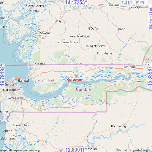
Kerewan GPS coordinates[2]
13° 29' 23.28" North, 16° 5' 19.644" West
| Map corner | latitude | longitude |
|---|---|---|
| Upper-left | 14.17253°, | -16.79192° |
| Center: | 13.4898°, | -16.08879° |
| Lower-right: | 12.80511°, | -15.38567° |
| Map W x H: | 152×152 km | = 94.4×94.4mi |
| max Lat: | 13.8° ⇑39% North |
| Kerewan: | 13.4898° |
| min Lat: | ⇓61% South 13.20194° |
| min Long | Kerewan | max Long |
| -16.73389° | -16.08879° | -13.85° |
| W 12.2%⇐ | ⇒87.8% E |
Elevation
Elevation of Kerewan is 16 m = 52 ft, and this is 5.1 m = 17 ft below average elevation for this country.
| Max E: |
49 m = 161 ft | 64.2% |
| Avg. | 21.1 m = 69 ft | |
| Kerewan | 16 m = 52 ft | |
Min E: |
1 m = 3 ft | 35.8% |
See also: Gambia elevation on elevation.city.
Geographical zone
Kerewan is located in North Torrid zone (between Equator and Tropic of Cancer). Distance of this Northern Tropic circle is 1106 km =687.2 mi to North.| Distance of | km | miles | from Kerewan |
|---|---|---|---|
| North Pole | 8507.1 | 5286.1 | to North |
| Arctic Circle | 5901.2 | 3666.8 | to North |
| Tropic Cancer | 1106 | 687.2 | to North |
| Equator | 1499.9 | 932 | to South |


Nearby cities:
15 places around Kerewan: (largest is in red/bold)
• Bajana
29.4 km =18.3 mi,  130°
130°
• Chilla
22.1 km =13.7 mi,  287°
287°
• Daru Rilwan
13.2 km =8.2 mi,  59°
59°
• Dobo
14.8 km =9.2 mi, 63°
• Gunjur
7.5 km =4.7 mi, 60°
• Jali
20.4 km =12.7 mi,  139°
139°
• Janneh Kunda
13.3 km =8.3 mi,  203°
203°
• Keneba
19.6 km =12.2 mi,  155°
155°
• Kinteh Kunda
3 km =1.9 mi,  50°
50°
• Kuli Kunda
25.5 km =15.8 mi, 133°
• Mayork
31.4 km =19.5 mi, 155°
• No Kunda
28.9 km =18 mi,  72°
72°
• Saba
5.2 km =3.2 mi, 55°
• Tambana
9.4 km =5.8 mi,  280°
280°
• Tankular
9.8 km =6.1 mi,  145°
145°
Sources, notices
• [Note1] Compared only with cities in Gambia existing in our database
• [Src1] Map data: © OpenStreetMap contributors (CC-BY-SA)
• [Src2] Other city data from geonames.org with taken over terms of usage.
• [Src3] Geographical zone / Annual Mean Temperature by Robert A. Rohde @ Wikipedia
