Áfra geodata
Áfra (Ionian Islands) is a populated place; located in Greece in Europe/Athens (GMT+3) time zone. With population of 839 people, there are 1213 cities with bigger population in this country. Compared to other cities in Greece, 60.5% of cities are located further ↓South; 98.7% of cities are located further →East and 56.8% of cities have higher elevation than Áfra. Note1


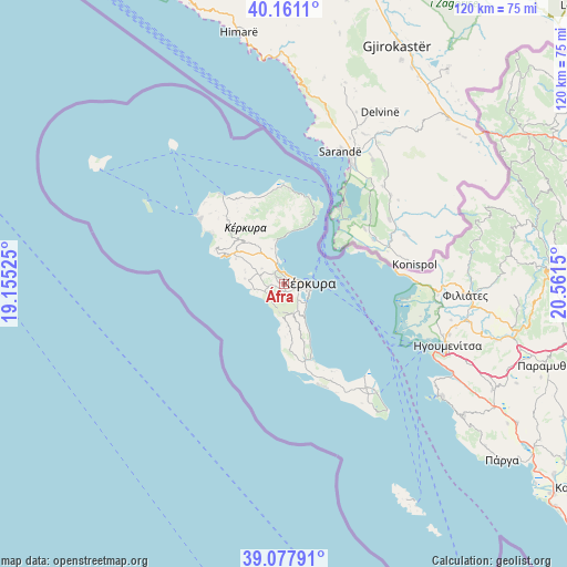
Áfra GPS coordinates[2]
39° 37' 17.832" North, 19° 51' 30.132" East
| Map corner | latitude | longitude |
|---|---|---|
| Upper-left | 40.1611°, | 19.15525° |
| Center: | 39.62162°, | 19.85837° |
| Lower-right: | 39.07791°, | 20.5615° |
| Map W x H: | 120.4×120.4 km | = 74.8×74.8mi |
| max Lat: | 41.72048° ⇑39.5% North |
| Áfra: | 39.62162° |
| min Lat: | ⇓60.5% South 34.8346° |
| min Long | Áfra | max Long |
| 19.40494° | 19.85837° | 29.59361° |
| W 1.3%⇐ | ⇒98.7% E |
Elevation
Elevation of Áfra is 60 m = 197 ft, and this is 108.9 m = 357 ft below average elevation for this country.
| Max E: |
1439 m = 4721 ft | 56.8% |
| Avg. | 168.9 m = 554 ft | |
| Áfra | 60 m = 197 ft | |
Min E: |
0 m = 0 ft | 43.2% |
See also: Greece elevation on elevation.city.
Geographical zone
Áfra is located in North temperate zone (between Tropic of Cancer and the Arctic Circle). Distance of this Northern Tropic circle is 1799.6 km =1118.2 mi to South.| Distance of | km | miles | from Áfra |
|---|---|---|---|
| North Pole | 5601.6 | 3480.7 | to North |
| Arctic Circle | 2995.7 | 1861.4 | to North |
| Tropic Cancer | 1799.6 | 1118.2 | to South |
| Equator | 4405.5 | 2737.4 | to South |


Nearby cities:
15 places around Áfra: (largest is in red/bold)
• Alepoú
3.3 km =2.1 mi,  101°
101°
• Chrysiída
4.8 km =3 mi,  136°
136°
• Corfu
5.3 km =3.3 mi,  91°
91°
• Gouviá
3.7 km =2.3 mi,  338°
338°
• Kanáli
3.4 km =2.1 mi,  121°
121°
• Kastanéa
3.9 km =2.4 mi, 144°
• Kokkínion
4 km =2.5 mi,  249°
249°
• Kompítsion
2 km =1.2 mi,  157°
157°
• Kontokáli
2.6 km =1.6 mi,  347°
347°
• Kyrá Chrysikoú
2.9 km =1.8 mi,  316°
316°
• Límni
4.7 km =2.9 mi, 349°
• Perama
6.3 km =3.9 mi,  133°
133°
• Potamós
1.7 km =1.1 mi,  80°
80°
• Virós
4.7 km =2.9 mi,  153°
153°
• Ágios Ioánnis
1.1 km =0.7 mi,  234°
234°
Sources, notices
• [Note1] Compared only with cities in Greece existing in our database
• [Src1] Map data: © OpenStreetMap contributors (CC-BY-SA)
• [Src2] Other city data from geonames.org with taken over terms of usage.
• [Src3] Geographical zone / Annual Mean Temperature by Robert A. Rohde @ Wikipedia
