Platýs Gialós geodata
Platýs Gialós (South Aegean) is a populated place; located in Greece in Europe/Athens (GMT+3) time zone. With population of 833 people, there are 1225 cities with bigger population in this country. Compared to other cities in Greece, 86.8% of cities are located further ↑North; 89.7% of cities are located further ←West and 90.7% of cities have higher elevation than Platýs Gialós. Note1


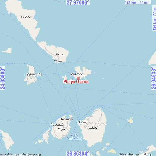
Platýs Gialós GPS coordinates[2]
37° 24' 52.128" North, 25° 20' 31.92" East
| Map corner | latitude | longitude |
|---|---|---|
| Upper-left | 37.97086°, | 24.63908° |
| Center: | 37.41448°, | 25.3422° |
| Lower-right: | 36.85394°, | 26.04533° |
| Map W x H: | 124.2×124.2 km | = 77.2×77.2mi |
| max Lat: | 41.72048° ⇑86.8% North |
| Platýs Gialós: | 37.41448° |
| min Lat: | ⇓13.2% South 34.8346° |
| min Long | Platýs Gialós | max Long |
| 19.40494° | 25.3422° | 29.59361° |
| W 89.7%⇐ | ⇒10.3% E |
Elevation
Elevation of Platýs Gialós is 8 m = 26 ft, and this is 160.9 m = 528 ft below average elevation for this country.
| Max E: |
1439 m = 4721 ft | 90.7% |
| Avg. | 168.9 m = 554 ft | |
| Platýs Gialós | 8 m = 26 ft | |
Min E: |
0 m = 0 ft | 9.3% |
See also: Greece elevation on elevation.city.
Geographical zone
Platýs Gialós is located in North temperate zone (between Tropic of Cancer and the Arctic Circle). Distance of this Northern Tropic circle is 1554.2 km =965.7 mi to South.| Distance of | km | miles | from Platýs Gialós |
|---|---|---|---|
| North Pole | 5847 | 3633.2 | to North |
| Arctic Circle | 3241.1 | 2013.9 | to North |
| Tropic Cancer | 1554.2 | 965.7 | to South |
| Equator | 4160.1 | 2585 | to South |


Nearby cities:
15 places around Platýs Gialós: (largest is in red/bold)
• Ermoúpolis
35.4 km =22 mi,  275°
275°
• Glinádo
38.6 km =24 mi,  172°
172°
• Klouvás
4.3 km =2.7 mi,  7°
7°
• Kóronos
37.1 km =23.1 mi,  152°
152°
• Mykonos
3.6 km =2.2 mi,  340°
340°
• Náousa
33.8 km =21 mi,  195°
195°
• Náxos
34.5 km =21.4 mi, 174°
• Ornós
2 km =1.2 mi,  301°
301°
• Plintrí
2.1 km =1.3 mi,  55°
55°
• Toúrlos
5.5 km =3.4 mi,  348°
348°
• Tínos
20.9 km =13 mi,  310°
310°
• Vári
34.8 km =21.6 mi,  267°
267°
• Ágios Arsénios
39.5 km =24.5 mi, 173°
• Áno Merá
5.8 km =3.6 mi,  48°
48°
• Áno Sýros
36.1 km =22.4 mi, 276°
Sources, notices
• [Note1] Compared only with cities in Greece existing in our database
• [Src1] Map data: © OpenStreetMap contributors (CC-BY-SA)
• [Src2] Other city data from geonames.org with taken over terms of usage.
• [Src3] Geographical zone / Annual Mean Temperature by Robert A. Rohde @ Wikipedia
