Tínos geodata
Tínos (South Aegean) is a seat of a third-order administrative division; located in Greece in Europe/Athens (GMT+3) time zone. With population of 4,573 people, there are 255 cities with bigger population in this country. Compared to other cities in Greece, 85.7% of cities are located further ↑North; 88.4% of cities are located further ←West and 92.5% of cities have higher elevation than Tínos. Note1


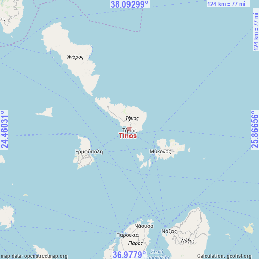
Tínos GPS coordinates[2]
37° 32' 15.108" North, 25° 9' 48.348" East
| Map corner | latitude | longitude |
|---|---|---|
| Upper-left | 38.09299°, | 24.46031° |
| Center: | 37.53753°, | 25.16343° |
| Lower-right: | 36.9779°, | 25.86656° |
| Map W x H: | 124×124 km | = 77.1×77.1mi |
| max Lat: | 41.72048° ⇑85.7% North |
| Tínos: | 37.53753° |
| min Lat: | ⇓14.3% South 34.8346° |
| min Long | Tínos | max Long |
| 19.40494° | 25.16343° | 29.59361° |
| W 88.4%⇐ | ⇒11.6% E |
Elevation
Elevation of Tínos is 7 m = 23 ft, and this is 161.9 m = 531 ft below average elevation for this country.
| Max E: |
1439 m = 4721 ft | 92.5% |
| Avg. | 168.9 m = 554 ft | |
| Tínos | 7 m = 23 ft | |
Min E: |
0 m = 0 ft | 7.5% |
See also: Greece elevation on elevation.city.
Geographical zone
Tínos is located in North temperate zone (between Tropic of Cancer and the Arctic Circle). Distance of this Northern Tropic circle is 1567.9 km =974.2 mi to South.| Distance of | km | miles | from Tínos |
|---|---|---|---|
| North Pole | 5833.3 | 3624.6 | to North |
| Arctic Circle | 3227.4 | 2005.4 | to North |
| Tropic Cancer | 1567.9 | 974.2 | to South |
| Equator | 4173.8 | 2593.5 | to South |


Nearby cities:
15 places around Tínos: (largest is in red/bold)
• Andros
38.6 km =24 mi,  328°
328°
• Ermoúpolis
22 km =13.7 mi,  242°
242°
• Klouvás
18.9 km =11.7 mi,  120°
120°
• Mykonos
17.8 km =11.1 mi,  125°
125°
• Náousa
46.7 km =29 mi,  171°
171°
• Náxos
51.6 km =32.1 mi,  158°
158°
• Ornós
18.9 km =11.7 mi, 131°
• Platýs Gialós
20.9 km =13 mi, 130°
• Plintrí
21.5 km =13.4 mi, 125°
• Páros
50.5 km =31.4 mi,  181°
181°
• Toúrlos
16.9 km =10.5 mi, 119°
• Vári
24.4 km =15.2 mi,  230°
230°
• Áno Merá
22.4 km =13.9 mi, 116°
• Áno Sýros
22.3 km =13.9 mi, 244°
• Órmos Korthíou
32.3 km =20.1 mi,  324°
324°
Sources, notices
• [Note1] Compared only with cities in Greece existing in our database
• [Src1] Map data: © OpenStreetMap contributors (CC-BY-SA)
• [Src2] Other city data from geonames.org with taken over terms of usage.
• [Src3] Geographical zone / Annual Mean Temperature by Robert A. Rohde @ Wikipedia
