Agía Galíni geodata
Agía Galíni (Crete) is a populated place; located in Greece in Europe/Athens (GMT+3) time zone. With population of 1,369 people, there are 743 cities with bigger population in this country. Compared to other cities in Greece, 98.8% of cities are located further ↑North; 84.7% of cities are located further ←West and 74.1% of cities have higher elevation than Agía Galíni. Note1


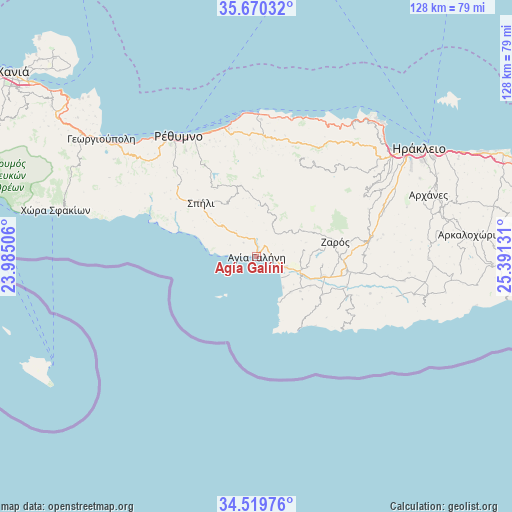
Agía Galíni GPS coordinates[2]
35° 5' 49.452" North, 24° 41' 17.448" East
| Map corner | latitude | longitude |
|---|---|---|
| Upper-left | 35.67032°, | 23.98506° |
| Center: | 35.09707°, | 24.68818° |
| Lower-right: | 34.51976°, | 25.39131° |
| Map W x H: | 127.9×127.9 km | = 79.5×79.5mi |
| max Lat: | 41.72048° ⇑98.8% North |
| Agía Galíni: | 35.09707° |
| min Lat: | ⇓1.2% South 34.8346° |
| min Long | Agía Galíni | max Long |
| 19.40494° | 24.68818° | 29.59361° |
| W 84.7%⇐ | ⇒15.3% E |
Elevation
Elevation of Agía Galíni is 25 m = 82 ft, and this is 143.9 m = 472 ft below average elevation for this country.
| Max E: |
1439 m = 4721 ft | 74.1% |
| Avg. | 168.9 m = 554 ft | |
| Agía Galíni | 25 m = 82 ft | |
Min E: |
0 m = 0 ft | 25.9% |
See also: Greece elevation on elevation.city.
Geographical zone
Agía Galíni is located in North temperate zone (between Tropic of Cancer and the Arctic Circle). Distance of this Northern Tropic circle is 1296.5 km =805.6 mi to South.| Distance of | km | miles | from Agía Galíni |
|---|---|---|---|
| North Pole | 6104.6 | 3793.2 | to North |
| Arctic Circle | 3498.7 | 2174 | to North |
| Tropic Cancer | 1296.5 | 805.6 | to South |
| Equator | 3902.4 | 2424.8 | to South |


Nearby cities:
15 places around Agía Galíni: (largest is in red/bold)
• Agía Foteiní
18.2 km =11.3 mi,  344°
344°
• Agía Varvára
28.8 km =17.9 mi,  81°
81°
• Anógeia
27.9 km =17.3 mi,  39°
39°
• Galiá
16.7 km =10.4 mi,  97°
97°
• Gérgeri
24.1 km =15 mi, 80°
• Moíres
17.6 km =10.9 mi,  106°
106°
• Pitsídia
12.4 km =7.7 mi,  136°
136°
• Pérama
30.4 km =18.9 mi,  2°
2°
• Pómpia
19 km =11.8 mi,  120°
120°
• Spílion
19.5 km =12.1 mi,  314°
314°
• Tympáki
7.8 km =4.8 mi, 110°
• Vóroi
11.6 km =7.2 mi, 106°
• Zarós
20 km =12.4 mi, 79°
• Zonianá
25.5 km =15.8 mi,  30°
30°
• Ágioi Déka
25.6 km =15.9 mi, 97°
Sources, notices
• [Note1] Compared only with cities in Greece existing in our database
• [Src1] Map data: © OpenStreetMap contributors (CC-BY-SA)
• [Src2] Other city data from geonames.org with taken over terms of usage.
• [Src3] Geographical zone / Annual Mean Temperature by Robert A. Rohde @ Wikipedia
