Foúrnoi geodata
Foúrnoi (North Aegean) is a seat of a third-order administrative division; located in Greece in Europe/Athens (GMT+3) time zone. In our database, there are 1823 cities with bigger population. Compared to other cities in Greece, 85.1% of cities are located further ↑North; 96.6% of cities are located further ←West and 85.7% of cities have higher elevation than Foúrnoi. Note1
Administrative division(s):
- Level 1: North Aegean
- Level 2: Nomós Sámou
- Level 3: Dimos Fournoi Korseon


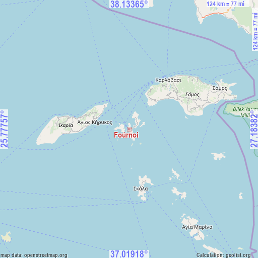
Foúrnoi GPS coordinates[2]
37° 34' 42.6" North, 26° 28' 50.484" East
| Map corner | latitude | longitude |
|---|---|---|
| Upper-left | 38.13365°, | 25.77757° |
| Center: | 37.5785°, | 26.48069° |
| Lower-right: | 37.01918°, | 27.18382° |
| Map W x H: | 123.9×123.9 km | = 77×77mi |
| max Lat: | 41.72048° ⇑85.1% North |
| Foúrnoi: | 37.5785° |
| min Lat: | ⇓14.9% South 34.8346° |
| min Long | Foúrnoi | max Long |
| 19.40494° | 26.48069° | 29.59361° |
| W 96.6%⇐ | ⇒3.4% E |
Elevation
Elevation of Foúrnoi is 12 m = 39 ft, and this is 156.9 m = 515 ft below average elevation for this country.
| Max E: |
1439 m = 4721 ft | 85.7% |
| Avg. | 168.9 m = 554 ft | |
| Foúrnoi | 12 m = 39 ft | |
Min E: |
0 m = 0 ft | 14.3% |
See also: Greece elevation on elevation.city.
Geographical zone
Foúrnoi is located in North temperate zone (between Tropic of Cancer and the Arctic Circle). Distance of this Northern Tropic circle is 1572.4 km =977 mi to South.| Distance of | km | miles | from Foúrnoi |
|---|---|---|---|
| North Pole | 5828.7 | 3621.8 | to North |
| Arctic Circle | 3222.8 | 2002.6 | to North |
| Tropic Cancer | 1572.4 | 977 | to South |
| Equator | 4178.3 | 2596.3 | to South |


Nearby cities:
15 places around Foúrnoi: (largest is in red/bold)
• Agios Kirykos
16.9 km =10.5 mi,  283°
283°
• Chóra
39.8 km =24.7 mi,  69°
69°
• Iraío
36.6 km =22.7 mi, 74°
• Kokkári
42.5 km =26.4 mi,  58°
58°
• Kontakaíika
34 km =21.1 mi,  43°
43°
• Kámbos
26 km =16.2 mi,  164°
164°
• Leipsoí
41.4 km =25.7 mi,  142°
142°
• Marathókampos
24.7 km =15.3 mi,  48°
48°
• Megálo Chorió
45.4 km =28.2 mi,  107°
107°
• Mytilinioí
41 km =25.5 mi, 66°
• Néon Karlovásion
30.9 km =19.2 mi, 39°
• Pagóndas
32.6 km =20.3 mi, 71°
• Pythagóreio
42.6 km =26.5 mi, 72°
• Pátmos
30.5 km =19 mi,  168°
168°
• Skála
29 km =18 mi, 169°
Sources, notices
• [Note1] Compared only with cities in Greece existing in our database
• [Src1] Map data: © OpenStreetMap contributors (CC-BY-SA)
• [Src2] Other city data from geonames.org with taken over terms of usage.
• [Src3] Geographical zone / Annual Mean Temperature by Robert A. Rohde @ Wikipedia
