Skála geodata
Skála (South Aegean) is a populated place; located in Greece in Europe/Athens (GMT+3) time zone. With population of 1,747 people, there are 585 cities with bigger population in this country. Compared to other cities in Greece, 87.6% of cities are located further ↑North; 97.1% of cities are located further ←West and 95.6% of cities have higher elevation than Skála. Note1


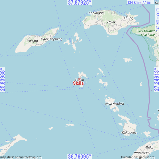
Skála GPS coordinates[2]
37° 19' 19.848" North, 26° 32' 34.8" East
| Map corner | latitude | longitude |
|---|---|---|
| Upper-left | 37.87925°, | 25.83988° |
| Center: | 37.32218°, | 26.543° |
| Lower-right: | 36.76095°, | 27.24613° |
| Map W x H: | 124.3×124.3 km | = 77.2×77.2mi |
| max Lat: | 41.72048° ⇑87.6% North |
| Skála: | 37.32218° |
| min Lat: | ⇓12.4% South 34.8346° |
| min Long | Skála | max Long |
| 19.40494° | 26.543° | 29.59361° |
| W 97.1%⇐ | ⇒2.9% E |
Elevation
Elevation of Skála is 5 m = 16 ft, and this is 163.9 m = 538 ft below average elevation for this country.
| Max E: |
1439 m = 4721 ft | 95.6% |
| Avg. | 168.9 m = 554 ft | |
| Skála | 5 m = 16 ft | |
Min E: |
0 m = 0 ft | 4.4% |
See also: Greece elevation on elevation.city.
Geographical zone
Skála is located in North temperate zone (between Tropic of Cancer and the Arctic Circle). Distance of this Northern Tropic circle is 1543.9 km =959.3 mi to South.| Distance of | km | miles | from Skála |
|---|---|---|---|
| North Pole | 5857.2 | 3639.5 | to North |
| Arctic Circle | 3251.3 | 2020.3 | to North |
| Tropic Cancer | 1543.9 | 959.3 | to South |
| Equator | 4149.8 | 2578.6 | to South |


Nearby cities:
15 places around Skála: (largest is in red/bold)
• Agios Kirykos
39.2 km =24.4 mi,  326°
326°
• Agía Marína
33.1 km =20.6 mi,  124°
124°
• Chóra
53.1 km =33 mi,  36°
36°
• Foúrnoi
29 km =18 mi,  349°
349°
• Iraío
48.4 km =30.1 mi, 38°
• Kamara
30.8 km =19.1 mi,  125°
125°
• Kámbos
3.7 km =2.3 mi,  20°
20°
• Lakkí
34.5 km =21.4 mi, 127°
• Leipsoí
20.2 km =12.6 mi,  102°
102°
• Marathókampos
46.8 km =29.1 mi, 16°
• Megálo Chorió
40.9 km =25.4 mi,  68°
68°
• Pagóndas
46.4 km =28.8 mi,  33°
33°
• Pánormos
52.4 km =32.6 mi,  138°
138°
• Pátmos
1.5 km =0.9 mi,  165°
165°
• Xirókampos
37.1 km =23.1 mi, 129°
Sources, notices
• [Note1] Compared only with cities in Greece existing in our database
• [Src1] Map data: © OpenStreetMap contributors (CC-BY-SA)
• [Src2] Other city data from geonames.org with taken over terms of usage.
• [Src3] Geographical zone / Annual Mean Temperature by Robert A. Rohde @ Wikipedia
