Marathókampos geodata
Marathókampos (North Aegean) is a populated place; located in Greece in Europe/Athens (GMT+3) time zone. With population of 1,069 people, there are 944 cities with bigger population in this country. Compared to other cities in Greece, 82.1% of cities are located further ↑North; 97.5% of cities are located further ←West and 77.4% of cities have lower elevation than Marathókampos. Note1


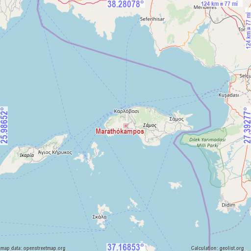
Marathókampos GPS coordinates[2]
37° 43' 36.264" North, 26° 41' 22.704" East
| Map corner | latitude | longitude |
|---|---|---|
| Upper-left | 38.28078°, | 25.98652° |
| Center: | 37.72674°, | 26.68964° |
| Lower-right: | 37.16853°, | 27.39277° |
| Map W x H: | 123.7×123.7 km | = 76.9×76.9mi |
| max Lat: | 41.72048° ⇑82.1% North |
| Marathókampos: | 37.72674° |
| min Lat: | ⇓17.9% South 34.8346° |
| min Long | Marathókampos | max Long |
| 19.40494° | 26.68964° | 29.59361° |
| W 97.5%⇐ | ⇒2.5% E |
Elevation
Elevation of Marathókampos is 240 m = 787 ft, and this is 71.1 m = 233 ft above average elevation for this country.
| Max E: |
1439 m = 4721 ft | 22.6% |
| Marathókampos | 240 m 787 ft | |
| Avg. | 168.9 m = 554 ft | |
Min E: |
0 m = 0 ft | 77.4% |
See also: Greece elevation on elevation.city.
Geographical zone
Marathókampos is located in North temperate zone (between Tropic of Cancer and the Arctic Circle). Distance of this Northern Tropic circle is 1588.9 km =987.3 mi to South.| Distance of | km | miles | from Marathókampos |
|---|---|---|---|
| North Pole | 5812.2 | 3611.5 | to North |
| Arctic Circle | 3206.4 | 1992.4 | to North |
| Tropic Cancer | 1588.9 | 987.3 | to South |
| Equator | 4194.8 | 2606.5 | to South |


Nearby cities:
15 places around Marathókampos: (largest is in red/bold)
• Agios Kirykos
36.9 km =22.9 mi,  250°
250°
• Chóra
19.1 km =11.9 mi,  97°
97°
• Foúrnoi
24.7 km =15.3 mi,  228°
228°
• Iraío
18.2 km =11.3 mi,  112°
112°
• Kokkári
18.7 km =11.6 mi,  71°
71°
• Kontakaíika
9.7 km =6 mi,  29°
29°
• Kámbos
43.2 km =26.8 mi,  195°
195°
• Megálo Chorió
38.9 km =24.2 mi,  140°
140°
• Mytilinioí
19.2 km =11.9 mi,  89°
89°
• Néon Karlovásion
7.4 km =4.6 mi,  10°
10°
• Pagóndas
13.9 km =8.6 mi,  116°
116°
• Palaiókastro
27.3 km =17 mi, 87°
• Pythagóreio
22.7 km =14.1 mi, 100°
• Samos
25.5 km =15.8 mi,  83°
83°
• Vathý
25.9 km =16.1 mi, 85°
Sources, notices
• [Note1] Compared only with cities in Greece existing in our database
• [Src1] Map data: © OpenStreetMap contributors (CC-BY-SA)
• [Src2] Other city data from geonames.org with taken over terms of usage.
• [Src3] Geographical zone / Annual Mean Temperature by Robert A. Rohde @ Wikipedia
