Gérgeri geodata
Gérgeri (Crete) is a populated place; located in Greece in Europe/Athens (GMT+3) time zone. With population of 1,444 people, there are 695 cities with bigger population in this country. Compared to other cities in Greece, 98.5% of cities are located further ↑North; 86.7% of cities are located further ←West and 90.4% of cities have lower elevation than Gérgeri. Note1


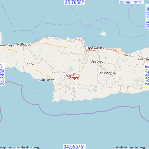
Gérgeri GPS coordinates[2]
35° 7' 58.116" North, 24° 56' 58.668" East
| Map corner | latitude | longitude |
|---|---|---|
| Upper-left | 35.7058°, | 24.24651° |
| Center: | 35.13281°, | 24.94963° |
| Lower-right: | 34.55575°, | 25.65276° |
| Map W x H: | 127.9×127.9 km | = 79.5×79.5mi |
| max Lat: | 41.72048° ⇑98.5% North |
| Gérgeri: | 35.13281° |
| min Lat: | ⇓1.5% South 34.8346° |
| min Long | Gérgeri | max Long |
| 19.40494° | 24.94963° | 29.59361° |
| W 86.7%⇐ | ⇒13.3% E |
Elevation
Elevation of Gérgeri is 512 m = 1680 ft, and this is 343.1 m = 1126 ft above average elevation for this country.
| Max E: |
1439 m = 4721 ft | 9.6% |
| Gérgeri | 512 m 1680 ft | |
| Avg. | 168.9 m = 554 ft | |
Min E: |
0 m = 0 ft | 90.4% |
See also: Greece elevation on elevation.city.
Geographical zone
Gérgeri is located in North temperate zone (between Tropic of Cancer and the Arctic Circle). Distance of this Northern Tropic circle is 1300.5 km =808.1 mi to South.| Distance of | km | miles | from Gérgeri |
|---|---|---|---|
| North Pole | 6100.7 | 3790.8 | to North |
| Arctic Circle | 3494.8 | 2171.6 | to North |
| Tropic Cancer | 1300.5 | 808.1 | to South |
| Equator | 3906.4 | 2427.3 | to South |


Nearby cities:
15 places around Gérgeri: (largest is in red/bold)
• Agía Varvára
4.7 km =2.9 mi,  84°
84°
• Anógeia
18.6 km =11.6 mi,  341°
341°
• Asímion
16.4 km =10.2 mi,  127°
127°
• Galiá
9.5 km =5.9 mi,  229°
229°
• Krousón
11.3 km =7 mi,  15°
15°
• Káto Asítai
8.9 km =5.5 mi,  29°
29°
• Moíres
11.4 km =7.1 mi,  217°
217°
• Profítis Ilías
15.9 km =9.9 mi,  59°
59°
• Pómpia
15.6 km =9.7 mi,  208°
208°
• Tympáki
17.8 km =11.1 mi,  247°
247°
• Tílisos
19.1 km =11.9 mi, 18°
• Veneráton
10.9 km =6.8 mi,  49°
49°
• Vóroi
14.6 km =9.1 mi,  240°
240°
• Zarós
4.1 km =2.5 mi,  266°
266°
• Ágioi Déka
7.5 km =4.7 mi,  168°
168°
Sources, notices
• [Note1] Compared only with cities in Greece existing in our database
• [Src1] Map data: © OpenStreetMap contributors (CC-BY-SA)
• [Src2] Other city data from geonames.org with taken over terms of usage.
• [Src3] Geographical zone / Annual Mean Temperature by Robert A. Rohde @ Wikipedia
