Vóroi geodata
Vóroi (Crete) is a populated place; located in Greece in Europe/Athens (GMT+3) time zone. With population of 726 people, there are 1368 cities with bigger population in this country. Compared to other cities in Greece, 99% of cities are located further ↑North; 85.7% of cities are located further ←West and 57.4% of cities have higher elevation than Vóroi. Note1


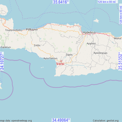
Vóroi GPS coordinates[2]
35° 4' 5.34" North, 24° 48' 37.404" East
| Map corner | latitude | longitude |
|---|---|---|
| Upper-left | 35.6416°, | 24.10727° |
| Center: | 35.06815°, | 24.81039° |
| Lower-right: | 34.49064°, | 25.51352° |
| Map W x H: | 128×128 km | = 79.5×79.5mi |
| max Lat: | 41.72048° ⇑99% North |
| Vóroi: | 35.06815° |
| min Lat: | ⇓1% South 34.8346° |
| min Long | Vóroi | max Long |
| 19.40494° | 24.81039° | 29.59361° |
| W 85.7%⇐ | ⇒14.3% E |
Elevation
Elevation of Vóroi is 58 m = 190 ft, and this is 110.9 m = 364 ft below average elevation for this country.
| Max E: |
1439 m = 4721 ft | 57.4% |
| Avg. | 168.9 m = 554 ft | |
| Vóroi | 58 m = 190 ft | |
Min E: |
0 m = 0 ft | 42.6% |
See also: Greece elevation on elevation.city.
Geographical zone
Vóroi is located in North temperate zone (between Tropic of Cancer and the Arctic Circle). Distance of this Northern Tropic circle is 1293.3 km =803.6 mi to South.| Distance of | km | miles | from Vóroi |
|---|---|---|---|
| North Pole | 6107.8 | 3795.2 | to North |
| Arctic Circle | 3502 | 2176 | to North |
| Tropic Cancer | 1293.3 | 803.6 | to South |
| Equator | 3899.2 | 2422.8 | to South |


Nearby cities:
15 places around Vóroi: (largest is in red/bold)
• Agía Galíni
11.6 km =7.2 mi,  286°
286°
• Agía Varvára
19 km =11.8 mi,  66°
66°
• Anógeia
25.7 km =16 mi,  15°
15°
• Galiá
5.5 km =3.4 mi,  78°
78°
• Gérgeri
14.6 km =9.1 mi,  60°
60°
• Krousón
23.9 km =14.9 mi,  40°
40°
• Káto Asítai
22.7 km =14.1 mi,  48°
48°
• Moíres
6 km =3.7 mi,  107°
107°
• Pitsídia
6.4 km =4 mi,  204°
204°
• Pómpia
8.3 km =5.2 mi,  141°
141°
• Tympáki
3.8 km =2.4 mi,  277°
277°
• Veneráton
25.4 km =15.8 mi, 55°
• Zarós
11 km =6.8 mi, 50°
• Zonianá
25.3 km =15.7 mi,  3°
3°
• Ágioi Déka
14.2 km =8.8 mi,  90°
90°
Sources, notices
• [Note1] Compared only with cities in Greece existing in our database
• [Src1] Map data: © OpenStreetMap contributors (CC-BY-SA)
• [Src2] Other city data from geonames.org with taken over terms of usage.
• [Src3] Geographical zone / Annual Mean Temperature by Robert A. Rohde @ Wikipedia
