Moíres geodata
Moíres (Crete) is a seat of a third-order administrative division; located in Greece in Europe/Athens (GMT+3) time zone. With population of 6,379 people, there are 198 cities with bigger population in this country. Compared to other cities in Greece, 99.1% of cities are located further ↑North; 86% of cities are located further ←West and 50.9% of cities have lower elevation than Moíres. Note1


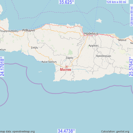
Moíres GPS coordinates[2]
35° 3' 5.148" North, 24° 52' 23.88" East
| Map corner | latitude | longitude |
|---|---|---|
| Upper-left | 35.625°, | 24.17018° |
| Center: | 35.05143°, | 24.8733° |
| Lower-right: | 34.4738°, | 25.57643° |
| Map W x H: | 128×128 km | = 79.5×79.5mi |
| max Lat: | 41.72048° ⇑99.1% North |
| Moíres: | 35.05143° |
| min Lat: | ⇓0.9% South 34.8346° |
| min Long | Moíres | max Long |
| 19.40494° | 24.8733° | 29.59361° |
| W 86%⇐ | ⇒14% E |
Elevation
Elevation of Moíres is 84 m = 276 ft, and this is 84.9 m = 279 ft below average elevation for this country.
| Max E: |
1439 m = 4721 ft | 49.1% |
| Avg. | 168.9 m = 554 ft | |
| Moíres | 84 m = 276 ft | |
Min E: |
0 m = 0 ft | 50.9% |
See also: Greece elevation on elevation.city.
Geographical zone
Moíres is located in North temperate zone (between Tropic of Cancer and the Arctic Circle). Distance of this Northern Tropic circle is 1291.4 km =802.4 mi to South.| Distance of | km | miles | from Moíres |
|---|---|---|---|
| North Pole | 6109.7 | 3796.4 | to North |
| Arctic Circle | 3503.8 | 2177.2 | to North |
| Tropic Cancer | 1291.4 | 802.4 | to South |
| Equator | 3897.4 | 2421.7 | to South |


Nearby cities:
15 places around Moíres: (largest is in red/bold)
• Agía Galíni
17.6 km =10.9 mi,  286°
286°
• Agía Varvára
15 km =9.3 mi,  50°
50°
• Asímion
20 km =12.4 mi,  92°
92°
• Galiá
3 km =1.9 mi,  354°
354°
• Gérgeri
11.4 km =7.1 mi,  37°
37°
• Krousón
22.3 km =13.9 mi,  26°
26°
• Káto Asítai
20.3 km =12.6 mi, 34°
• Pitsídia
9.3 km =5.8 mi,  244°
244°
• Pómpia
4.7 km =2.9 mi,  186°
186°
• Pýrgos
25.9 km =16.1 mi,  101°
101°
• Tympáki
9.8 km =6.1 mi,  284°
284°
• Veneráton
22.2 km =13.8 mi, 43°
• Vóroi
6 km =3.7 mi, 287°
• Zarós
9.2 km =5.7 mi,  17°
17°
• Ágioi Déka
8.7 km =5.4 mi,  78°
78°
Sources, notices
• [Note1] Compared only with cities in Greece existing in our database
• [Src1] Map data: © OpenStreetMap contributors (CC-BY-SA)
• [Src2] Other city data from geonames.org with taken over terms of usage.
• [Src3] Geographical zone / Annual Mean Temperature by Robert A. Rohde @ Wikipedia
