Kíssamos geodata
Kíssamos (Crete) is a seat of a third-order administrative division; located in Greece in Europe/Athens (GMT+3) time zone. With population of 4,236 people, there are 270 cities with bigger population in this country. Compared to other cities in Greece, 94.4% of cities are located further ↑North; 68.3% of cities are located further ←West and 76.9% of cities have higher elevation than Kíssamos. Note1


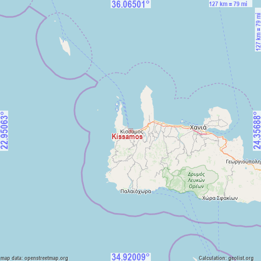
Kíssamos GPS coordinates[2]
35° 29' 40.524" North, 23° 39' 13.5" East
| Map corner | latitude | longitude |
|---|---|---|
| Upper-left | 36.06501°, | 22.95063° |
| Center: | 35.49459°, | 23.65375° |
| Lower-right: | 34.92009°, | 24.35688° |
| Map W x H: | 127.3×127.3 km | = 79.1×79.1mi |
| max Lat: | 41.72048° ⇑94.4% North |
| Kíssamos: | 35.49459° |
| min Lat: | ⇓5.6% South 34.8346° |
| min Long | Kíssamos | max Long |
| 19.40494° | 23.65375° | 29.59361° |
| W 68.3%⇐ | ⇒31.7% E |
Elevation
Elevation of Kíssamos is 21 m = 69 ft, and this is 147.9 m = 485 ft below average elevation for this country.
| Max E: |
1439 m = 4721 ft | 76.9% |
| Avg. | 168.9 m = 554 ft | |
| Kíssamos | 21 m = 69 ft | |
Min E: |
0 m = 0 ft | 23.1% |
See also: Greece elevation on elevation.city.
Geographical zone
Kíssamos is located in North temperate zone (between Tropic of Cancer and the Arctic Circle). Distance of this Northern Tropic circle is 1340.7 km =833.1 mi to South.| Distance of | km | miles | from Kíssamos |
|---|---|---|---|
| North Pole | 6060.4 | 3765.8 | to North |
| Arctic Circle | 3454.5 | 2146.5 | to North |
| Tropic Cancer | 1340.7 | 833.1 | to South |
| Equator | 3946.6 | 2452.3 | to South |


Nearby cities:
15 places around Kíssamos: (largest is in red/bold)
• Agía Marína
24.8 km =15.4 mi,  84°
84°
• Chaniá
34 km =21.1 mi,  86°
86°
• Darátsos
29.1 km =18.1 mi, 88°
• Galatás
28 km =17.4 mi, 89°
• Geráni
20.5 km =12.7 mi, 82°
• Gialós
28.5 km =17.7 mi,  183°
183°
• Kolympári
12.5 km =7.8 mi,  65°
65°
• Mourniés
32.5 km =20.2 mi, 92°
• Nerokoúros
35 km =21.7 mi, 93°
• Palaióchora
29.4 km =18.3 mi, 175°
• Perivólia
30.8 km =19.1 mi, 91°
• Plátanos
5.2 km =3.2 mi,  242°
242°
• Stalós
26.2 km =16.3 mi, 86°
• Tavronítis
15.6 km =9.7 mi, 75°
• Tsikalariá
37.1 km =23.1 mi, 93°
Sources, notices
• [Note1] Compared only with cities in Greece existing in our database
• [Src1] Map data: © OpenStreetMap contributors (CC-BY-SA)
• [Src2] Other city data from geonames.org with taken over terms of usage.
• [Src3] Geographical zone / Annual Mean Temperature by Robert A. Rohde @ Wikipedia
