Mýtikas geodata
Mýtikas (Epirus) is a populated place; located in Greece in Europe/Athens (GMT+3) time zone. With population of 866 people, there are 1179 cities with bigger population in this country. Compared to other cities in Greece, 54.5% of cities are located further ↑North; 95.4% of cities are located further →East and 84.7% of cities have higher elevation than Mýtikas. Note1


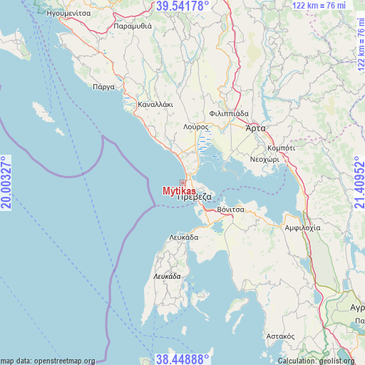
Mýtikas GPS coordinates[2]
38° 59' 50.784" North, 20° 42' 23.004" East
| Map corner | latitude | longitude |
|---|---|---|
| Upper-left | 39.54178°, | 20.00327° |
| Center: | 38.99744°, | 20.70639° |
| Lower-right: | 38.44888°, | 21.40952° |
| Map W x H: | 121.5×121.5 km | = 75.5×75.5mi |
| max Lat: | 41.72048° ⇑54.5% North |
| Mýtikas: | 38.99744° |
| min Lat: | ⇓45.5% South 34.8346° |
| min Long | Mýtikas | max Long |
| 19.40494° | 20.70639° | 29.59361° |
| W 4.6%⇐ | ⇒95.4% E |
Elevation
Elevation of Mýtikas is 13 m = 43 ft, and this is 155.9 m = 511 ft below average elevation for this country.
| Max E: |
1439 m = 4721 ft | 84.7% |
| Avg. | 168.9 m = 554 ft | |
| Mýtikas | 13 m = 43 ft | |
Min E: |
0 m = 0 ft | 15.3% |
See also: Greece elevation on elevation.city.
Geographical zone
Mýtikas is located in North temperate zone (between Tropic of Cancer and the Arctic Circle). Distance of this Northern Tropic circle is 1730.2 km =1075.1 mi to South.| Distance of | km | miles | from Mýtikas |
|---|---|---|---|
| North Pole | 5671 | 3523.8 | to North |
| Arctic Circle | 3065.1 | 1904.6 | to North |
| Tropic Cancer | 1730.2 | 1075.1 | to South |
| Equator | 4336.1 | 2694.3 | to South |


Nearby cities:
15 places around Mýtikas: (largest is in red/bold)
• Apólpaina
20.3 km =12.6 mi,  184°
184°
• Kanáli
8.1 km =5 mi,  356°
356°
• Lefkáda
18.6 km =11.6 mi, 180°
• Loúros
19.2 km =11.9 mi,  12°
12°
• Néa Sampsoúnta
10.7 km =6.6 mi,  17°
17°
• Néa Sinópi
9.6 km =6 mi, 9°
• Néos Oropós
17.2 km =10.7 mi, 8°
• Oropós
18.5 km =11.5 mi,  3°
3°
• Préveza
6 km =3.7 mi,  140°
140°
• Pétra
20.2 km =12.6 mi,  28°
28°
• Ráchi
21.1 km =13.1 mi,  52°
52°
• Tsoukaládhes
20 km =12.4 mi,  192°
192°
• Vónitsa
18 km =11.2 mi,  120°
120°
• Ágios Nikólaos
16.6 km =10.3 mi,  149°
149°
• Ágios Spyrídon
21.2 km =13.2 mi,  39°
39°
Sources, notices
• [Note1] Compared only with cities in Greece existing in our database
• [Src1] Map data: © OpenStreetMap contributors (CC-BY-SA)
• [Src2] Other city data from geonames.org with taken over terms of usage.
• [Src3] Geographical zone / Annual Mean Temperature by Robert A. Rohde @ Wikipedia
