Vamvakoú geodata
Vamvakoú (Thessaly) is a populated place; located in Greece in Europe/Athens (GMT+3) time zone. With population of 1,104 people, there are 917 cities with bigger population in this country. Compared to other cities in Greece, 52.3% of cities are located further ↓South; 62% of cities are located further →East and 67.5% of cities have lower elevation than Vamvakoú. Note1


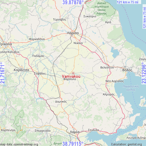
Vamvakoú GPS coordinates[2]
39° 20' 13.488" North, 22° 25' 11.388" East
| Map corner | latitude | longitude |
|---|---|---|
| Upper-left | 39.87878°, | 21.71671° |
| Center: | 39.33708°, | 22.41983° |
| Lower-right: | 38.79115°, | 23.12296° |
| Map W x H: | 120.9×120.9 km | = 75.1×75.1mi |
| max Lat: | 41.72048° ⇑47.7% North |
| Vamvakoú: | 39.33708° |
| min Lat: | ⇓52.3% South 34.8346° |
| min Long | Vamvakoú | max Long |
| 19.40494° | 22.41983° | 29.59361° |
| W 38%⇐ | ⇒62% E |
Elevation
Elevation of Vamvakoú is 150 m = 492 ft, and this is 18.9 m = 62 ft below average elevation for this country.
| Max E: |
1439 m = 4721 ft | 32.5% |
| Avg. | 168.9 m = 554 ft | |
| Vamvakoú | 150 m = 492 ft | |
Min E: |
0 m = 0 ft | 67.5% |
See also: Greece elevation on elevation.city.
Geographical zone
Vamvakoú is located in North temperate zone (between Tropic of Cancer and the Arctic Circle). Distance of this Northern Tropic circle is 1768 km =1098.6 mi to South.| Distance of | km | miles | from Vamvakoú |
|---|---|---|---|
| North Pole | 5633.2 | 3500.3 | to North |
| Arctic Circle | 3027.3 | 1881.1 | to North |
| Tropic Cancer | 1768 | 1098.6 | to South |
| Equator | 4373.9 | 2717.8 | to South |


Nearby cities:
15 places around Vamvakoú: (largest is in red/bold)
• Arméni
29.2 km =18.1 mi,  54°
54°
• Chálki
27.7 km =17.2 mi,  21°
21°
• Domokós
25.5 km =15.8 mi,  203°
203°
• Ekkára
28 km =17.4 mi,  223°
223°
• Eleftherés
27.7 km =17.2 mi,  345°
345°
• Fársala
5.6 km =3.5 mi,  212°
212°
• Itéa
25.6 km =15.9 mi,  301°
301°
• Koiláda
28.1 km =17.5 mi,  339°
339°
• Néon Monastírion
16.5 km =10.3 mi,  229°
229°
• Níkaia
25.8 km =16 mi,  8°
8°
• Omvriakí
29.2 km =18.1 mi, 206°
• Rizómylos
29.9 km =18.6 mi,  70°
70°
• Sofádes
27.5 km =17.1 mi,  269°
269°
• Velestíno
28.5 km =17.7 mi,  79°
79°
• Ágios Geórgios Ferón
30.9 km =19.2 mi, 83°
Sources, notices
• [Note1] Compared only with cities in Greece existing in our database
• [Src1] Map data: © OpenStreetMap contributors (CC-BY-SA)
• [Src2] Other city data from geonames.org with taken over terms of usage.
• [Src3] Geographical zone / Annual Mean Temperature by Robert A. Rohde @ Wikipedia
