Sofádes geodata
Sofádes (Thessaly) is a seat of a third-order administrative division; located in Greece in Europe/Athens (GMT+3) time zone. In our database, there are 1823 cities with bigger population. Compared to other cities in Greece, 52.2% of cities are located further ↓South; 69.8% of cities are located further →East and 58.3% of cities have lower elevation than Sofádes. Note1


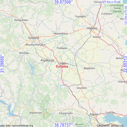
Sofádes GPS coordinates[2]
39° 19' 59.988" North, 22° 6' 0" East
| Map corner | latitude | longitude |
|---|---|---|
| Upper-left | 39.87506°, | 21.39688° |
| Center: | 39.33333°, | 22.1° |
| Lower-right: | 38.78737°, | 22.80313° |
| Map W x H: | 120.9×120.9 km | = 75.1×75.1mi |
| max Lat: | 41.72048° ⇑47.8% North |
| Sofádes: | 39.33333° |
| min Lat: | ⇓52.2% South 34.8346° |
| min Long | Sofádes | max Long |
| 19.40494° | 22.1° | 29.59361° |
| W 30.2%⇐ | ⇒69.8% E |
Elevation
Elevation of Sofádes is 110 m = 361 ft, and this is 58.9 m = 193 ft below average elevation for this country.
| Max E: |
1439 m = 4721 ft | 41.7% |
| Avg. | 168.9 m = 554 ft | |
| Sofádes | 110 m = 361 ft | |
Min E: |
0 m = 0 ft | 58.3% |
See also: Greece elevation on elevation.city.
Geographical zone
Sofádes is located in North temperate zone (between Tropic of Cancer and the Arctic Circle). Distance of this Northern Tropic circle is 1767.5 km =1098.3 mi to South.| Distance of | km | miles | from Sofádes |
|---|---|---|---|
| North Pole | 5633.6 | 3500.6 | to North |
| Arctic Circle | 3027.7 | 1881.3 | to North |
| Tropic Cancer | 1767.5 | 1098.3 | to South |
| Equator | 4373.5 | 2717.6 | to South |


Nearby cities:
15 places around Sofádes: (largest is in red/bold)
• Anávra
16 km =9.9 mi,  182°
182°
• Itéa
14.8 km =9.2 mi,  22°
22°
• Kallifóni
13.5 km =8.4 mi,  242°
242°
• Karditsomagoúla
16.5 km =10.3 mi,  292°
292°
• Kardítsa
15.7 km =9.8 mi,  282°
282°
• Karpochóri
7.6 km =4.7 mi,  272°
272°
• Makrychóri
16.5 km =10.3 mi,  315°
315°
• Mavrika
13.7 km =8.5 mi, 274°
• Mýrina
14.4 km =8.9 mi,  305°
305°
• Palamás
14.9 km =9.3 mi,  354°
354°
• Palioúri
16.2 km =10.1 mi,  218°
218°
• Pródromos
11.7 km =7.3 mi, 293°
• Roússo
17 km =10.6 mi,  262°
262°
• Stavrós
11.5 km =7.1 mi, 286°
• Zaḯmi
14.3 km =8.9 mi,  254°
254°
Sources, notices
• [Note1] Compared only with cities in Greece existing in our database
• [Src1] Map data: © OpenStreetMap contributors (CC-BY-SA)
• [Src2] Other city data from geonames.org with taken over terms of usage.
• [Src3] Geographical zone / Annual Mean Temperature by Robert A. Rohde @ Wikipedia
