Domokós geodata
Domokós (Central Greece) is a seat of a third-order administrative division; located in Greece in Europe/Athens (GMT+3) time zone. With population of 1,531 people, there are 648 cities with bigger population in this country. Compared to other cities in Greece, 52.4% of cities are located further ↑North; 65.3% of cities are located further →East and 92.1% of cities have lower elevation than Domokós. Note1
Administrative division(s):
- Level 1: Central Greece
- Level 2: Nomós Fthiótidos
- Level 3: Dimos Domokos


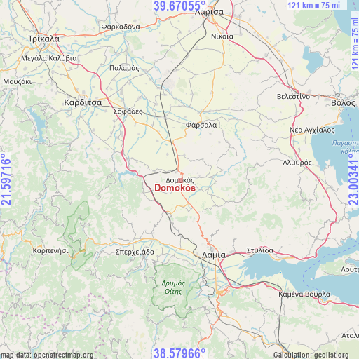
Domokós GPS coordinates[2]
39° 7' 37.992" North, 22° 18' 1.008" East
| Map corner | latitude | longitude |
|---|---|---|
| Upper-left | 39.67055°, | 21.59716° |
| Center: | 39.12722°, | 22.30028° |
| Lower-right: | 38.57966°, | 23.00341° |
| Map W x H: | 121.3×121.3 km | = 75.4×75.4mi |
| max Lat: | 41.72048° ⇑52.4% North |
| Domokós: | 39.12722° |
| min Lat: | ⇓47.6% South 34.8346° |
| min Long | Domokós | max Long |
| 19.40494° | 22.30028° | 29.59361° |
| W 34.7%⇐ | ⇒65.3% E |
Elevation
Elevation of Domokós is 576 m = 1890 ft, and this is 407.1 m = 1336 ft above average elevation for this country.
| Max E: |
1439 m = 4721 ft | 7.9% |
| Domokós | 576 m 1890 ft | |
| Avg. | 168.9 m = 554 ft | |
Min E: |
0 m = 0 ft | 92.1% |
See also: Greece elevation on elevation.city.
Geographical zone
Domokós is located in North temperate zone (between Tropic of Cancer and the Arctic Circle). Distance of this Northern Tropic circle is 1744.6 km =1084 mi to South.| Distance of | km | miles | from Domokós |
|---|---|---|---|
| North Pole | 5656.5 | 3514.8 | to North |
| Arctic Circle | 3050.6 | 1895.6 | to North |
| Tropic Cancer | 1744.6 | 1084 | to South |
| Equator | 4350.5 | 2703.3 | to South |


Nearby cities:
15 places around Domokós: (largest is in red/bold)
• Anávra
19.2 km =11.9 mi,  291°
291°
• Anávra
22.5 km =14 mi,  105°
105°
• Ekkára
9.4 km =5.8 mi, 288°
• Fársala
20 km =12.4 mi,  21°
21°
• Lamía
27.8 km =17.3 mi,  155°
155°
• Lianokládhion
23.4 km =14.5 mi,  179°
179°
• Makrakómi
26.1 km =16.2 mi,  217°
217°
• Mexiátai
27.2 km =16.9 mi, 177°
• Néon Monastírion
12.7 km =7.9 mi,  349°
349°
• Omvriakí
3.8 km =2.4 mi, 221°
• Rentína
28.6 km =17.8 mi,  255°
255°
• Sofádes
28.7 km =17.8 mi,  323°
323°
• Spercheiáda
28.7 km =17.8 mi,  211°
211°
• Stavrós
26.4 km =16.4 mi,  166°
166°
• Vamvakoú
25.5 km =15.8 mi, 23°
Sources, notices
• [Note1] Compared only with cities in Greece existing in our database
• [Src1] Map data: © OpenStreetMap contributors (CC-BY-SA)
• [Src2] Other city data from geonames.org with taken over terms of usage.
• [Src3] Geographical zone / Annual Mean Temperature by Robert A. Rohde @ Wikipedia
