Fársala geodata
Fársala (Thessaly) is a seat of a third-order administrative division; located in Greece in Europe/Athens (GMT+3) time zone. With population of 10,380 people, there are 138 cities with bigger population in this country. Compared to other cities in Greece, 51.2% of cities are located further ↓South; 63.1% of cities are located further →East and 66.5% of cities have lower elevation than Fársala. Note1


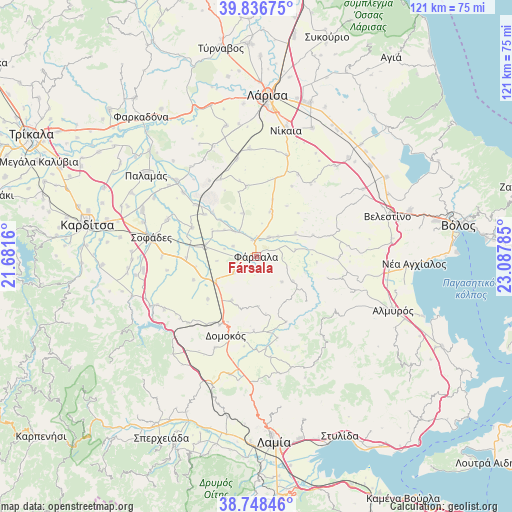
Fársala GPS coordinates[2]
39° 17' 40.992" North, 22° 23' 4.992" East
| Map corner | latitude | longitude |
|---|---|---|
| Upper-left | 39.83675°, | 21.6816° |
| Center: | 39.29472°, | 22.38472° |
| Lower-right: | 38.74846°, | 23.08785° |
| Map W x H: | 121×121 km | = 75.2×75.2mi |
| max Lat: | 41.72048° ⇑48.8% North |
| Fársala: | 39.29472° |
| min Lat: | ⇓51.2% South 34.8346° |
| min Long | Fársala | max Long |
| 19.40494° | 22.38472° | 29.59361° |
| W 36.9%⇐ | ⇒63.1% E |
Elevation
Elevation of Fársala is 145 m = 476 ft, and this is 23.9 m = 78 ft below average elevation for this country.
| Max E: |
1439 m = 4721 ft | 33.5% |
| Avg. | 168.9 m = 554 ft | |
| Fársala | 145 m = 476 ft | |
Min E: |
0 m = 0 ft | 66.5% |
See also: Greece elevation on elevation.city.
Geographical zone
Fársala is located in North temperate zone (between Tropic of Cancer and the Arctic Circle). Distance of this Northern Tropic circle is 1763.2 km =1095.6 mi to South.| Distance of | km | miles | from Fársala |
|---|---|---|---|
| North Pole | 5637.9 | 3503.2 | to North |
| Arctic Circle | 3032 | 1884 | to North |
| Tropic Cancer | 1763.2 | 1095.6 | to South |
| Equator | 4369.2 | 2714.9 | to South |


Nearby cities:
15 places around Fársala: (largest is in red/bold)
• Anávra
27.7 km =17.2 mi,  245°
245°
• Anávra
28.5 km =17.7 mi,  149°
149°
• Domokós
20 km =12.4 mi,  201°
201°
• Ekkára
22.5 km =14 mi,  225°
225°
• Eleftherés
31.7 km =19.7 mi,  352°
352°
• Itéa
26 km =16.2 mi,  313°
313°
• Karpochóri
32.4 km =20.1 mi,  278°
278°
• Koiláda
31.8 km =19.8 mi, 347°
• Néon Monastírion
11.3 km =7 mi,  237°
237°
• Níkaia
31 km =19.3 mi,  13°
13°
• Omvriakí
23.6 km =14.7 mi, 204°
• Palamás
32.2 km =20 mi, 306°
• Sofádes
24.9 km =15.5 mi, 279°
• Vamvakoú
5.6 km =3.5 mi,  32°
32°
• Velestíno
32.6 km =20.3 mi,  72°
72°
Sources, notices
• [Note1] Compared only with cities in Greece existing in our database
• [Src1] Map data: © OpenStreetMap contributors (CC-BY-SA)
• [Src2] Other city data from geonames.org with taken over terms of usage.
• [Src3] Geographical zone / Annual Mean Temperature by Robert A. Rohde @ Wikipedia
