Itéa geodata
Itéa (Thessaly) is a populated place; located in Greece in Europe/Athens (GMT+3) time zone. With population of 1,301 people, there are 771 cities with bigger population in this country. Compared to other cities in Greece, 55.2% of cities are located further ↓South; 68.2% of cities are located further →East and 54.4% of cities have lower elevation than Itéa. Note1


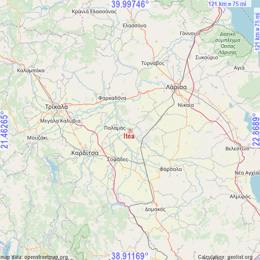
Itéa GPS coordinates[2]
39° 27' 24.084" North, 22° 9' 56.772" East
| Map corner | latitude | longitude |
|---|---|---|
| Upper-left | 39.99746°, | 21.46265° |
| Center: | 39.45669°, | 22.16577° |
| Lower-right: | 38.91169°, | 22.8689° |
| Map W x H: | 120.7×120.7 km | = 75×75mi |
| max Lat: | 41.72048° ⇑44.8% North |
| Itéa: | 39.45669° |
| min Lat: | ⇓55.2% South 34.8346° |
| min Long | Itéa | max Long |
| 19.40494° | 22.16577° | 29.59361° |
| W 31.8%⇐ | ⇒68.2% E |
Elevation
Elevation of Itéa is 97 m = 318 ft, and this is 71.9 m = 236 ft below average elevation for this country.
| Max E: |
1439 m = 4721 ft | 45.6% |
| Avg. | 168.9 m = 554 ft | |
| Itéa | 97 m = 318 ft | |
Min E: |
0 m = 0 ft | 54.4% |
See also: Greece elevation on elevation.city.
Geographical zone
Itéa is located in North temperate zone (between Tropic of Cancer and the Arctic Circle). Distance of this Northern Tropic circle is 1781.3 km =1106.8 mi to South.| Distance of | km | miles | from Itéa |
|---|---|---|---|
| North Pole | 5619.9 | 3492 | to North |
| Arctic Circle | 3014 | 1872.8 | to North |
| Tropic Cancer | 1781.3 | 1106.8 | to South |
| Equator | 4387.2 | 2726.1 | to South |


Nearby cities:
15 places around Itéa: (largest is in red/bold)
• Eleftherés
20 km =12.4 mi,  47°
47°
• Farkadóna
18.1 km =11.2 mi,  331°
331°
• Grizáno
21.8 km =13.5 mi, 333°
• Karpochóri
18.9 km =11.7 mi,  224°
224°
• Koiláda
17.6 km =10.9 mi,  42°
42°
• Makrychóri
17.3 km =10.7 mi,  263°
263°
• Marathéa
16.8 km =10.4 mi,  299°
299°
• Mándra
19.4 km =12.1 mi,  24°
24°
• Mýrina
18.2 km =11.3 mi,  252°
252°
• Palamás
7.2 km =4.5 mi,  278°
278°
• Pedinó
19.5 km =12.1 mi,  290°
290°
• Pródromos
18.7 km =11.6 mi,  241°
241°
• Sofádes
14.8 km =9.2 mi,  202°
202°
• Stavrós
19.7 km =12.2 mi, 237°
• Zárkos
17.3 km =10.7 mi,  347°
347°
Sources, notices
• [Note1] Compared only with cities in Greece existing in our database
• [Src1] Map data: © OpenStreetMap contributors (CC-BY-SA)
• [Src2] Other city data from geonames.org with taken over terms of usage.
• [Src3] Geographical zone / Annual Mean Temperature by Robert A. Rohde @ Wikipedia
