Páros geodata
Páros (South Aegean) is a seat of a third-order administrative division; located in Greece in Europe/Athens (GMT+3) time zone. With population of 5,289 people, there are 226 cities with bigger population in this country. Compared to other cities in Greece, 89% of cities are located further ↑North; 88.3% of cities are located further ←West and 87.7% of cities have higher elevation than Páros. Note1


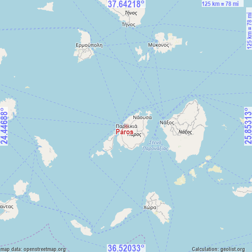
Páros GPS coordinates[2]
37° 4' 59.988" North, 25° 9' 0" East
| Map corner | latitude | longitude |
|---|---|---|
| Upper-left | 37.64218°, | 24.44688° |
| Center: | 37.08333°, | 25.15° |
| Lower-right: | 36.52033°, | 25.85313° |
| Map W x H: | 124.7×124.7 km | = 77.5×77.5mi |
| max Lat: | 41.72048° ⇑89% North |
| Páros: | 37.08333° |
| min Lat: | ⇓11% South 34.8346° |
| min Long | Páros | max Long |
| 19.40494° | 25.15° | 29.59361° |
| W 88.3%⇐ | ⇒11.7% E |
Elevation
Elevation of Páros is 10 m = 33 ft, and this is 158.9 m = 521 ft below average elevation for this country.
| Max E: |
1439 m = 4721 ft | 87.7% |
| Avg. | 168.9 m = 554 ft | |
| Páros | 10 m = 33 ft | |
Min E: |
0 m = 0 ft | 12.3% |
See also: Greece elevation on elevation.city.
Geographical zone
Páros is located in North temperate zone (between Tropic of Cancer and the Arctic Circle). Distance of this Northern Tropic circle is 1517.4 km =942.9 mi to South.| Distance of | km | miles | from Páros |
|---|---|---|---|
| North Pole | 5883.8 | 3656 | to North |
| Arctic Circle | 3277.9 | 2036.8 | to North |
| Tropic Cancer | 1517.4 | 942.9 | to South |
| Equator | 4123.3 | 2562.1 | to South |


Nearby cities:
15 places around Páros: (largest is in red/bold)
• Antíparos
7.7 km =4.8 mi,  230°
230°
• Apollonía
39.7 km =24.7 mi,  252°
252°
• Apérathos
32.8 km =20.4 mi,  92°
92°
• Artemón
39.4 km =24.5 mi, 253°
• Filótion
31.1 km =19.3 mi,  96°
96°
• Glinádo
22.4 km =13.9 mi, 93°
• Kóronos
34.4 km =21.4 mi,  83°
83°
• Náousa
9.1 km =5.7 mi,  61°
61°
• Náxos
20.2 km =12.6 mi, 82°
• Ornós
40.8 km =25.4 mi,  21°
21°
• Platýs Gialós
40.6 km =25.2 mi, 24°
• Vári
39.3 km =24.4 mi,  333°
333°
• Vívlos
23.1 km =14.4 mi, 96°
• Ágios Arsénios
21.6 km =13.4 mi, 96°
• Íos
40.7 km =25.3 mi,  163°
163°
Sources, notices
• [Note1] Compared only with cities in Greece existing in our database
• [Src1] Map data: © OpenStreetMap contributors (CC-BY-SA)
• [Src2] Other city data from geonames.org with taken over terms of usage.
• [Src3] Geographical zone / Annual Mean Temperature by Robert A. Rohde @ Wikipedia
