Andros geodata
Andros (South Aegean) is a populated place; located in Greece in Europe/Athens (GMT+3) time zone. With population of 1,556 people, there are 640 cities with bigger population in this country. Compared to other cities in Greece, 79% of cities are located further ↑North; 86.5% of cities are located further ←West and 83.9% of cities have higher elevation than Andros. Note1


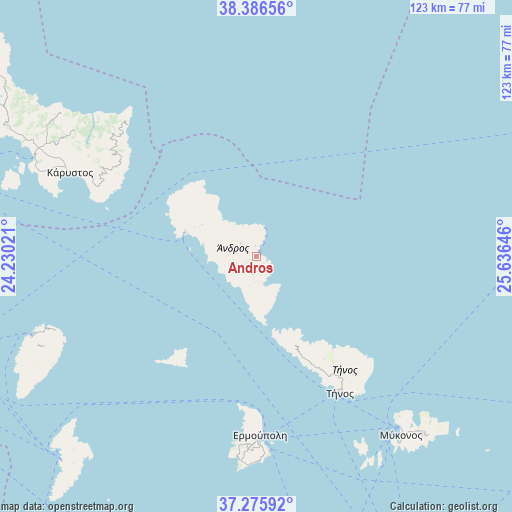
Andros GPS coordinates[2]
37° 49' 59.988" North, 24° 55' 59.988" East
| Map corner | latitude | longitude |
|---|---|---|
| Upper-left | 38.38656°, | 24.23021° |
| Center: | 37.83333°, | 24.93333° |
| Lower-right: | 37.27592°, | 25.63646° |
| Map W x H: | 123.5×123.5 km | = 76.7×76.7mi |
| max Lat: | 41.72048° ⇑79% North |
| Andros: | 37.83333° |
| min Lat: | ⇓21% South 34.8346° |
| min Long | Andros | max Long |
| 19.40494° | 24.93333° | 29.59361° |
| W 86.5%⇐ | ⇒13.5% E |
Elevation
Elevation of Andros is 14 m = 46 ft, and this is 154.9 m = 508 ft below average elevation for this country.
| Max E: |
1439 m = 4721 ft | 83.9% |
| Avg. | 168.9 m = 554 ft | |
| Andros | 14 m = 46 ft | |
Min E: |
0 m = 0 ft | 16.1% |
See also: Greece elevation on elevation.city.
Geographical zone
Andros is located in North temperate zone (between Tropic of Cancer and the Arctic Circle). Distance of this Northern Tropic circle is 1600.8 km =994.7 mi to South.| Distance of | km | miles | from Andros |
|---|---|---|---|
| North Pole | 5800.4 | 3604.2 | to North |
| Arctic Circle | 3194.5 | 1985 | to North |
| Tropic Cancer | 1600.8 | 994.7 | to South |
| Equator | 4206.7 | 2613.9 | to South |


Nearby cities:
15 places around Andros: (largest is in red/bold)
• Ermoúpolis
43.2 km =26.8 mi,  178°
178°
• Klouvás
55.9 km =34.7 mi,  139°
139°
• Kárystos
49.6 km =30.8 mi,  293°
293°
• Kéa
55.9 km =34.7 mi,  246°
246°
• Marmárion
58.8 km =36.5 mi, 293°
• Mykonos
55.4 km =34.4 mi, 141°
• Ornós
57 km =35.4 mi, 143°
• Platýs Gialós
58.9 km =36.6 mi, 142°
• Plintrí
59 km =36.7 mi, 140°
• Toúrlos
54 km =33.6 mi, 139°
• Tínos
38.6 km =24 mi,  148°
148°
• Vári
48.4 km =30.1 mi, 178°
• Áno Merá
58.7 km =36.5 mi, 136°
• Áno Sýros
42.6 km =26.5 mi, 179°
• Órmos Korthíou
6.8 km =4.2 mi,  167°
167°
Sources, notices
• [Note1] Compared only with cities in Greece existing in our database
• [Src1] Map data: © OpenStreetMap contributors (CC-BY-SA)
• [Src2] Other city data from geonames.org with taken over terms of usage.
• [Src3] Geographical zone / Annual Mean Temperature by Robert A. Rohde @ Wikipedia
