Stimánga geodata
Stimánga (Peloponnese) is a populated place; located in Greece in Europe/Athens (GMT+3) time zone. With population of 981 people, there are 1041 cities with bigger population in this country. Compared to other cities in Greece, 77.5% of cities are located further ↑North; 55.2% of cities are located further →East and 90.7% of cities have lower elevation than Stimánga. Note1
Administrative division(s):
- Level 1: Peloponnese
- Level 2: Nomós Korinthías
- Level 3: Dimos Velo-Vocha


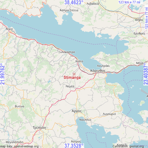
Stimánga GPS coordinates[2]
37° 54' 34.704" North, 22° 42' 2.664" East
| Map corner | latitude | longitude |
|---|---|---|
| Upper-left | 38.4623°, | 21.99762° |
| Center: | 37.90964°, | 22.70074° |
| Lower-right: | 37.3528°, | 23.40387° |
| Map W x H: | 123.4×123.4 km | = 76.7×76.7mi |
| max Lat: | 41.72048° ⇑77.5% North |
| Stimánga: | 37.90964° |
| min Lat: | ⇓22.5% South 34.8346° |
| min Long | Stimánga | max Long |
| 19.40494° | 22.70074° | 29.59361° |
| W 44.8%⇐ | ⇒55.2% E |
Elevation
Elevation of Stimánga is 519 m = 1703 ft, and this is 350.1 m = 1149 ft above average elevation for this country.
| Max E: |
1439 m = 4721 ft | 9.3% |
| Stimánga | 519 m 1703 ft | |
| Avg. | 168.9 m = 554 ft | |
Min E: |
0 m = 0 ft | 90.7% |
See also: Greece elevation on elevation.city.
Geographical zone
Stimánga is located in North temperate zone (between Tropic of Cancer and the Arctic Circle). Distance of this Northern Tropic circle is 1609.2 km =999.9 mi to South.| Distance of | km | miles | from Stimánga |
|---|---|---|---|
| North Pole | 5791.9 | 3598.9 | to North |
| Arctic Circle | 3186 | 1979.7 | to North |
| Tropic Cancer | 1609.2 | 999.9 | to South |
| Equator | 4215.2 | 2619.2 | to South |


Nearby cities:
15 places around Stimánga: (largest is in red/bold)
• ArchaÍes Kleonés
10.6 km =6.6 mi,  155°
155°
• Boláti
9.4 km =5.8 mi,  56°
56°
• Kokkónion
9.7 km =6 mi,  45°
45°
• Krionérion
8.2 km =5.1 mi,  316°
316°
• Krínes
8.2 km =5.1 mi,  40°
40°
• Moúlki
9.5 km =5.9 mi,  13°
13°
• Neméa
10.5 km =6.5 mi,  199°
199°
• Nerántza
10.9 km =6.8 mi, 40°
• Poullítsa
8.3 km =5.2 mi, 48°
• Sikyón
8.3 km =5.2 mi, 14°
• Vokhaïkó
9.1 km =5.7 mi, 61°
• Vrakháti
10.7 km =6.6 mi, 59°
• Vélo
9 km =5.6 mi, 35°
• Zevgolateió
9.1 km =5.7 mi,  73°
73°
• Ássos
11.2 km =7 mi, 72°
Sources, notices
• [Note1] Compared only with cities in Greece existing in our database
• [Src1] Map data: © OpenStreetMap contributors (CC-BY-SA)
• [Src2] Other city data from geonames.org with taken over terms of usage.
• [Src3] Geographical zone / Annual Mean Temperature by Robert A. Rohde @ Wikipedia
