Poullítsa geodata
Poullítsa (Peloponnese) is a populated place; located in Greece in Europe/Athens (GMT+3) time zone. With population of 696 people, there are 1417 cities with bigger population in this country. Compared to other cities in Greece, 75.6% of cities are located further ↑North; 52.7% of cities are located further →East and 71.4% of cities have higher elevation than Poullítsa. Note1
Administrative division(s):
- Level 1: Peloponnese
- Level 2: Nomós Korinthías
- Level 3: Dimos Velo-Vocha


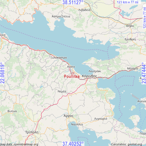
Poullítsa GPS coordinates[2]
37° 57' 32.364" North, 22° 46' 16.716" East
| Map corner | latitude | longitude |
|---|---|---|
| Upper-left | 38.51127°, | 22.06819° |
| Center: | 37.95899°, | 22.77131° |
| Lower-right: | 37.40252°, | 23.47444° |
| Map W x H: | 123.3×123.3 km | = 76.6×76.6mi |
| max Lat: | 41.72048° ⇑75.6% North |
| Poullítsa: | 37.95899° |
| min Lat: | ⇓24.4% South 34.8346° |
| min Long | Poullítsa | max Long |
| 19.40494° | 22.77131° | 29.59361° |
| W 47.3%⇐ | ⇒52.7% E |
Elevation
Elevation of Poullítsa is 29 m = 95 ft, and this is 139.9 m = 459 ft below average elevation for this country.
| Max E: |
1439 m = 4721 ft | 71.4% |
| Avg. | 168.9 m = 554 ft | |
| Poullítsa | 29 m = 95 ft | |
Min E: |
0 m = 0 ft | 28.6% |
See also: Greece elevation on elevation.city.
Geographical zone
Poullítsa is located in North temperate zone (between Tropic of Cancer and the Arctic Circle). Distance of this Northern Tropic circle is 1614.7 km =1003.3 mi to South.| Distance of | km | miles | from Poullítsa |
|---|---|---|---|
| North Pole | 5786.4 | 3595.5 | to North |
| Arctic Circle | 3180.5 | 1976.3 | to North |
| Tropic Cancer | 1614.7 | 1003.3 | to South |
| Equator | 4220.6 | 2622.6 | to South |


Nearby cities:
15 places around Poullítsa: (largest is in red/bold)
• Boláti
1.8 km =1.1 mi,  100°
100°
• Kiáto
6.4 km =4 mi,  341°
341°
• Kokkónion
1.5 km =0.9 mi,  31°
31°
• Krínes
1.2 km =0.7 mi,  310°
310°
• Káto Ássos
5.3 km =3.3 mi, 103°
• Moúlki
5.5 km =3.4 mi, 313°
• Nerántza
2.9 km =1.8 mi,  18°
18°
• Periyiáli
6.3 km =3.9 mi,  109°
109°
• Pásion
7.1 km =4.4 mi,  327°
327°
• Sikyón
4.8 km =3 mi,  302°
302°
• Vokhaïkó
2.2 km =1.4 mi,  122°
122°
• Vrakháti
3 km =1.9 mi,  90°
90°
• Vélo
2.2 km =1.4 mi, 332°
• Zevgolateió
3.8 km =2.4 mi,  138°
138°
• Ássos
5 km =3.1 mi, 115°
Sources, notices
• [Note1] Compared only with cities in Greece existing in our database
• [Src1] Map data: © OpenStreetMap contributors (CC-BY-SA)
• [Src2] Other city data from geonames.org with taken over terms of usage.
• [Src3] Geographical zone / Annual Mean Temperature by Robert A. Rohde @ Wikipedia
