Boláti geodata
Boláti (Peloponnese) is a populated place; located in Greece in Europe/Athens (GMT+3) time zone. With population of 767 people, there are 1309 cities with bigger population in this country. Compared to other cities in Greece, 75.8% of cities are located further ↑North; 51.9% of cities are located further →East and 78.7% of cities have higher elevation than Boláti. Note1
Administrative division(s):
- Level 1: Peloponnese
- Level 2: Nomós Korinthías
- Level 3: Dimos Velo-Vocha


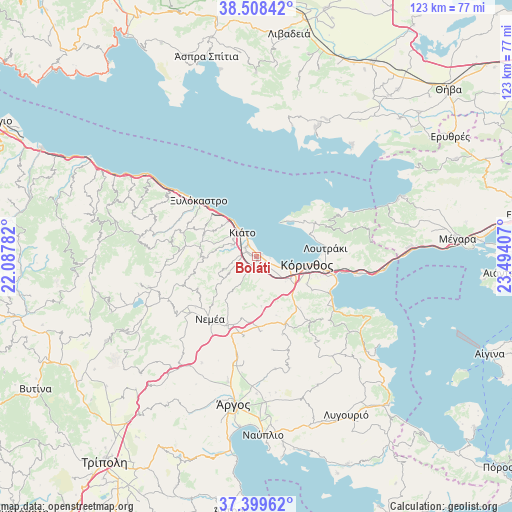
Boláti GPS coordinates[2]
37° 57' 21.996" North, 22° 47' 27.384" East
| Map corner | latitude | longitude |
|---|---|---|
| Upper-left | 38.50842°, | 22.08782° |
| Center: | 37.95611°, | 22.79094° |
| Lower-right: | 37.39962°, | 23.49407° |
| Map W x H: | 123.3×123.3 km | = 76.6×76.6mi |
| max Lat: | 41.72048° ⇑75.8% North |
| Boláti: | 37.95611° |
| min Lat: | ⇓24.2% South 34.8346° |
| min Long | Boláti | max Long |
| 19.40494° | 22.79094° | 29.59361° |
| W 48.1%⇐ | ⇒51.9% E |
Elevation
Elevation of Boláti is 19 m = 62 ft, and this is 149.9 m = 492 ft below average elevation for this country.
| Max E: |
1439 m = 4721 ft | 78.7% |
| Avg. | 168.9 m = 554 ft | |
| Boláti | 19 m = 62 ft | |
Min E: |
0 m = 0 ft | 21.3% |
See also: Greece elevation on elevation.city.
Geographical zone
Boláti is located in North temperate zone (between Tropic of Cancer and the Arctic Circle). Distance of this Northern Tropic circle is 1614.4 km =1003.1 mi to South.| Distance of | km | miles | from Boláti |
|---|---|---|---|
| North Pole | 5786.7 | 3595.7 | to North |
| Arctic Circle | 3180.9 | 1976.5 | to North |
| Tropic Cancer | 1614.4 | 1003.1 | to South |
| Equator | 4220.3 | 2622.4 | to South |


Nearby cities:
15 places around Boláti: (largest is in red/bold)
• Kiáto
7.4 km =4.6 mi,  329°
329°
• Kokkónion
1.9 km =1.2 mi, 329°
• Krínes
2.8 km =1.7 mi,  292°
292°
• Káto Ássos
3.6 km =2.2 mi,  105°
105°
• Lékhaio
5.8 km =3.6 mi,  116°
116°
• Moúlki
7.1 km =4.4 mi,  305°
305°
• Nerántza
3.2 km =2 mi,  345°
345°
• Periyiáli
4.6 km =2.9 mi, 112°
• Poullítsa
1.8 km =1.1 mi,  280°
280°
• Sikyón
6.5 km =4 mi,  296°
296°
• Vokhaïkó
0.9 km =0.6 mi,  173°
173°
• Vrakháti
1.3 km =0.8 mi,  76°
76°
• Vélo
3.5 km =2.2 mi, 309°
• Zevgolateió
2.7 km =1.7 mi,  162°
162°
• Ássos
3.3 km =2.1 mi, 123°
Sources, notices
• [Note1] Compared only with cities in Greece existing in our database
• [Src1] Map data: © OpenStreetMap contributors (CC-BY-SA)
• [Src2] Other city data from geonames.org with taken over terms of usage.
• [Src3] Geographical zone / Annual Mean Temperature by Robert A. Rohde @ Wikipedia
