Stános geodata
Stános (West Greece) is a populated place; located in Greece in Europe/Athens (GMT+3) time zone. With population of 1,132 people, there are 887 cities with bigger population in this country. Compared to other cities in Greece, 57.3% of cities are located further ↑North; 88.2% of cities are located further →East and 56.2% of cities have lower elevation than Stános. Note1
Administrative division(s):
- Level 1: West Greece
- Level 2: Nomós Aitolías kai Akarnanías
- Level 3: Dimos Amfilochia


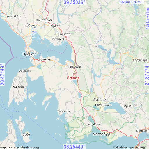
Stános GPS coordinates[2]
38° 48' 16.308" North, 21° 10' 28.596" East
| Map corner | latitude | longitude |
|---|---|---|
| Upper-left | 39.35036°, | 20.47149° |
| Center: | 38.80453°, | 21.17461° |
| Lower-right: | 38.25449°, | 21.87774° |
| Map W x H: | 121.8×121.8 km | = 75.7×75.7mi |
| max Lat: | 41.72048° ⇑57.3% North |
| Stános: | 38.80453° |
| min Lat: | ⇓42.7% South 34.8346° |
| min Long | Stános | max Long |
| 19.40494° | 21.17461° | 29.59361° |
| W 11.8%⇐ | ⇒88.2% E |
Elevation
Elevation of Stános is 102 m = 335 ft, and this is 66.9 m = 219 ft below average elevation for this country.
| Max E: |
1439 m = 4721 ft | 43.8% |
| Avg. | 168.9 m = 554 ft | |
| Stános | 102 m = 335 ft | |
Min E: |
0 m = 0 ft | 56.2% |
See also: Greece elevation on elevation.city.
Geographical zone
Stános is located in North temperate zone (between Tropic of Cancer and the Arctic Circle). Distance of this Northern Tropic circle is 1708.7 km =1061.7 mi to South.| Distance of | km | miles | from Stános |
|---|---|---|---|
| North Pole | 5692.4 | 3537.1 | to North |
| Arctic Circle | 3086.5 | 1917.9 | to North |
| Tropic Cancer | 1708.7 | 1061.7 | to South |
| Equator | 4314.7 | 2681 | to South |


Nearby cities:
15 places around Stános: (largest is in red/bold)
• Amfilochía
6.1 km =3.8 mi,  353°
353°
• Archontochóri
16.5 km =10.3 mi,  225°
225°
• Boúka
13.9 km =8.6 mi, 348°
• Fyteíes
12.2 km =7.6 mi,  175°
175°
• Katoúna
5.7 km =3.5 mi,  247°
247°
• Kríkellos
15.7 km =9.8 mi,  1°
1°
• Lepenoú
14.6 km =9.1 mi,  136°
136°
• Monastiráki
20.6 km =12.8 mi,  284°
284°
• Neápolis
22 km =13.7 mi,  132°
132°
• Sardínia
9.9 km =6.2 mi,  16°
16°
• Spoláïta
19.1 km =11.9 mi, 128°
• Strátos
19.5 km =12.1 mi, 141°
• Thýrio
17.7 km =11 mi,  288°
288°
• Trýfos
8.9 km =5.5 mi, 282°
• Ókhthia
18.9 km =11.7 mi,  149°
149°
Sources, notices
• [Note1] Compared only with cities in Greece existing in our database
• [Src1] Map data: © OpenStreetMap contributors (CC-BY-SA)
• [Src2] Other city data from geonames.org with taken over terms of usage.
• [Src3] Geographical zone / Annual Mean Temperature by Robert A. Rohde @ Wikipedia
