Sitia geodata
Sitia (Crete) is a seat of a third-order administrative division; located in Greece in Europe/Athens (GMT+3) time zone. With population of 8,707 people, there are 157 cities with bigger population in this country. Compared to other cities in Greece, 97.8% of cities are located further ↑North; 93.8% of cities are located further ←West and 80.3% of cities have higher elevation than Sitia. Note1


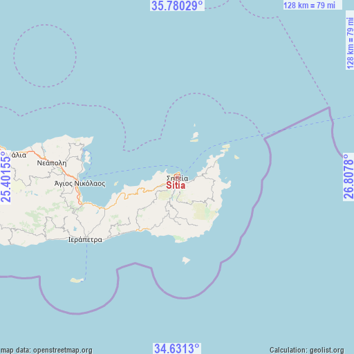
Sitia GPS coordinates[2]
35° 12' 28.188" North, 26° 6' 16.812" East
| Map corner | latitude | longitude |
|---|---|---|
| Upper-left | 35.78029°, | 25.40155° |
| Center: | 35.20783°, | 26.10467° |
| Lower-right: | 34.6313°, | 26.8078° |
| Map W x H: | 127.8×127.8 km | = 79.4×79.4mi |
| max Lat: | 41.72048° ⇑97.8% North |
| Sitia: | 35.20783° |
| min Lat: | ⇓2.2% South 34.8346° |
| min Long | Sitia | max Long |
| 19.40494° | 26.10467° | 29.59361° |
| W 93.8%⇐ | ⇒6.2% E |
Elevation
Elevation of Sitia is 17 m = 56 ft, and this is 151.9 m = 498 ft below average elevation for this country.
| Max E: |
1439 m = 4721 ft | 80.3% |
| Avg. | 168.9 m = 554 ft | |
| Sitia | 17 m = 56 ft | |
Min E: |
0 m = 0 ft | 19.7% |
See also: Greece elevation on elevation.city.
Geographical zone
Sitia is located in North temperate zone (between Tropic of Cancer and the Arctic Circle). Distance of this Northern Tropic circle is 1308.8 km =813.3 mi to South.| Distance of | km | miles | from Sitia |
|---|---|---|---|
| North Pole | 6092.3 | 3785.6 | to North |
| Arctic Circle | 3486.4 | 2166.3 | to North |
| Tropic Cancer | 1308.8 | 813.3 | to South |
| Equator | 3914.7 | 2432.5 | to South |


Nearby cities:
15 places around Sitia: (largest is in red/bold)
• Análipsi
21.8 km =13.5 mi,  211°
211°
• Eloúnda
35.4 km =22 mi,  280°
280°
• Férma
31 km =19.3 mi,  227°
227°
• Kavoúsi
24.3 km =15.1 mi,  247°
247°
• Koutsounári
33 km =20.5 mi, 229°
• Koutsourás
24.1 km =15 mi,  216°
216°
• Káto Chorió
33.6 km =20.9 mi,  238°
238°
• Makry-Gialos
22.5 km =14 mi, 212°
• Pacheía Ámmos
29 km =18 mi, 247°
• Palekastro
13.6 km =8.5 mi,  94°
94°
• Schísma Eloúndas
34.7 km =21.6 mi, 279°
• Vaïniá
36.5 km =22.7 mi, 236°
• Xirókambos
36.7 km =22.8 mi,  269°
269°
• Ágios Nikólaos
35.4 km =22 mi, 266°
• Ístro
34.5 km =21.4 mi, 254°
Sources, notices
• [Note1] Compared only with cities in Greece existing in our database
• [Src1] Map data: © OpenStreetMap contributors (CC-BY-SA)
• [Src2] Other city data from geonames.org with taken over terms of usage.
• [Src3] Geographical zone / Annual Mean Temperature by Robert A. Rohde @ Wikipedia
