Selládes geodata
Selládes (Epirus) is a populated place; located in Greece in Europe/Athens (GMT+3) time zone. With population of 718 people, there are 1386 cities with bigger population in this country. Compared to other cities in Greece, 52.7% of cities are located further ↑North; 89.2% of cities are located further →East and 51.9% of cities have higher elevation than Selládes. Note1


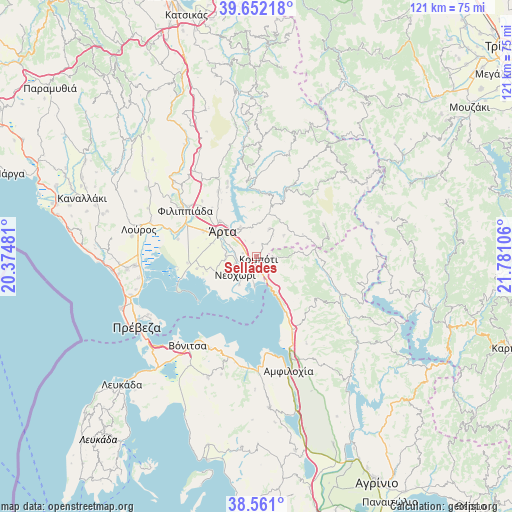
Selládes GPS coordinates[2]
39° 6' 31.32" North, 21° 4' 40.548" East
| Map corner | latitude | longitude |
|---|---|---|
| Upper-left | 39.65218°, | 20.37481° |
| Center: | 39.1087°, | 21.07793° |
| Lower-right: | 38.561°, | 21.78106° |
| Map W x H: | 121.3×121.3 km | = 75.4×75.4mi |
| max Lat: | 41.72048° ⇑52.7% North |
| Selládes: | 39.1087° |
| min Lat: | ⇓47.3% South 34.8346° |
| min Long | Selládes | max Long |
| 19.40494° | 21.07793° | 29.59361° |
| W 10.8%⇐ | ⇒89.2% E |
Elevation
Elevation of Selládes is 74 m = 243 ft, and this is 94.9 m = 311 ft below average elevation for this country.
| Max E: |
1439 m = 4721 ft | 51.9% |
| Avg. | 168.9 m = 554 ft | |
| Selládes | 74 m = 243 ft | |
Min E: |
0 m = 0 ft | 48.1% |
See also: Greece elevation on elevation.city.
Geographical zone
Selládes is located in North temperate zone (between Tropic of Cancer and the Arctic Circle). Distance of this Northern Tropic circle is 1742.6 km =1082.8 mi to South.| Distance of | km | miles | from Selládes |
|---|---|---|---|
| North Pole | 5658.6 | 3516.1 | to North |
| Arctic Circle | 3052.7 | 1896.9 | to North |
| Tropic Cancer | 1742.6 | 1082.8 | to South |
| Equator | 4348.5 | 2702 | to South |


Nearby cities:
15 places around Selládes: (largest is in red/bold)
• Agía Paraskeví
7.6 km =4.7 mi,  261°
261°
• Akropotamiá
5.2 km =3.2 mi,  252°
252°
• Eleoúsa
11.1 km =6.9 mi,  296°
296°
• Grammenítsa
12 km =7.5 mi,  314°
314°
• Komméno
7.9 km =4.9 mi,  210°
210°
• Kompóti
0.9 km =0.6 mi,  143°
143°
• Kostakioí
10.8 km =6.7 mi,  286°
286°
• Megárchi
3.3 km =2.1 mi,  347°
347°
• Menídi
8.2 km =5.1 mi,  154°
154°
• Neochóri
6.6 km =4.1 mi,  229°
229°
• Pachykálamos
6.2 km =3.9 mi,  243°
243°
• Péta
7.4 km =4.6 mi,  329°
329°
• Pétra
7.1 km =4.4 mi,  25°
25°
• Ágioi Anárgyroi
5.6 km =3.5 mi, 307°
• Árta
9.8 km =6.1 mi, 305°
Sources, notices
• [Note1] Compared only with cities in Greece existing in our database
• [Src1] Map data: © OpenStreetMap contributors (CC-BY-SA)
• [Src2] Other city data from geonames.org with taken over terms of usage.
• [Src3] Geographical zone / Annual Mean Temperature by Robert A. Rohde @ Wikipedia
