Samos geodata
Samos (North Aegean) is a seat of a second-order administrative division; located in Greece in Europe/Athens (GMT+3) time zone. With population of 1,885 people, there are 554 cities with bigger population in this country. Compared to other cities in Greece, 81.4% of cities are located further ↑North; 98.5% of cities are located further ←West and 99.6% of cities have higher elevation than Samos. Note1


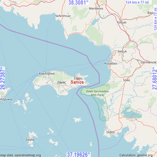
Samos GPS coordinates[2]
37° 45' 15.372" North, 26° 58' 37.164" East
| Map corner | latitude | longitude |
|---|---|---|
| Upper-left | 38.3081°, | 26.27387° |
| Center: | 37.75427°, | 26.97699° |
| Lower-right: | 37.19626°, | 27.68012° |
| Map W x H: | 123.6×123.6 km | = 76.8×76.8mi |
| max Lat: | 41.72048° ⇑81.4% North |
| Samos: | 37.75427° |
| min Lat: | ⇓18.6% South 34.8346° |
| min Long | Samos | max Long |
| 19.40494° | 26.97699° | 29.59361° |
| W 98.5%⇐ | ⇒1.5% E |
Elevation
Elevation of Samos is 1 m = 3 ft, and this is 167.9 m = 551 ft below average elevation for this country.
| Max E: |
1439 m = 4721 ft | 99.6% |
| Avg. | 168.9 m = 554 ft | |
| Samos | 1 m = 3 ft | |
Min E: |
0 m = 0 ft | 0.4% |
See also: Greece elevation on elevation.city.
Geographical zone
Samos is located in North temperate zone (between Tropic of Cancer and the Arctic Circle). Distance of this Northern Tropic circle is 1592 km =989.2 mi to South.| Distance of | km | miles | from Samos |
|---|---|---|---|
| North Pole | 5809.2 | 3609.7 | to North |
| Arctic Circle | 3203.3 | 1990.4 | to North |
| Tropic Cancer | 1592 | 989.2 | to South |
| Equator | 4197.9 | 2608.5 | to South |


Nearby cities:
15 places around Samos: (largest is in red/bold)
• Chóra
8.5 km =5.3 mi,  228°
228°
• Foúrnoi
47.9 km =29.8 mi,  245°
245°
• Iraío
13 km =8.1 mi,  220°
220°
• Kokkári
8 km =5 mi,  290°
290°
• Kontakaíika
21.1 km =13.1 mi,  284°
284°
• Kámbos
58 km =36 mi, 219°
• Leipsoí
55.6 km =34.5 mi,  199°
199°
• Marathókampos
25.5 km =15.8 mi,  263°
263°
• Megálo Chorió
32.9 km =20.4 mi,  180°
180°
• Mytilinioí
6.8 km =4.2 mi,  243°
243°
• Néon Karlovásion
24.3 km =15.1 mi, 279°
• Pagóndas
15.8 km =9.8 mi, 234°
• Palaiókastro
2.7 km =1.7 mi,  131°
131°
• Pythagóreio
7.6 km =4.7 mi, 202°
• Vathý
1 km =0.6 mi,  146°
146°
Sources, notices
• [Note1] Compared only with cities in Greece existing in our database
• [Src1] Map data: © OpenStreetMap contributors (CC-BY-SA)
• [Src2] Other city data from geonames.org with taken over terms of usage.
• [Src3] Geographical zone / Annual Mean Temperature by Robert A. Rohde @ Wikipedia
