Limnokhórion geodata
Limnokhórion (West Greece) is a populated place; located in Greece in Europe/Athens (GMT+3) time zone. With population of 1,213 people, there are 818 cities with bigger population in this country. Compared to other cities in Greece, 69.2% of cities are located further ↑North; 83.3% of cities are located further →East and 74.1% of cities have higher elevation than Limnokhórion. Note1


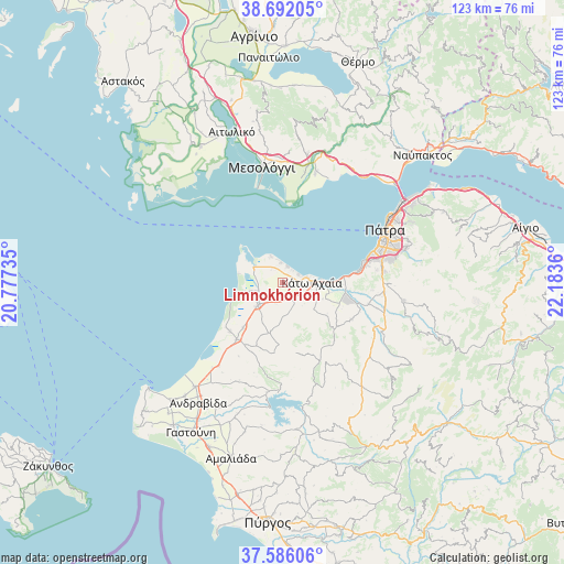
Limnokhórion GPS coordinates[2]
38° 8' 28.14" North, 21° 28' 49.692" East
| Map corner | latitude | longitude |
|---|---|---|
| Upper-left | 38.69205°, | 20.77735° |
| Center: | 38.14115°, | 21.48047° |
| Lower-right: | 37.58606°, | 22.1836° |
| Map W x H: | 123×123 km | = 76.4×76.4mi |
| max Lat: | 41.72048° ⇑69.2% North |
| Limnokhórion: | 38.14115° |
| min Lat: | ⇓30.8% South 34.8346° |
| min Long | Limnokhórion | max Long |
| 19.40494° | 21.48047° | 29.59361° |
| W 16.7%⇐ | ⇒83.3% E |
Elevation
Elevation of Limnokhórion is 25 m = 82 ft, and this is 143.9 m = 472 ft below average elevation for this country.
| Max E: |
1439 m = 4721 ft | 74.1% |
| Avg. | 168.9 m = 554 ft | |
| Limnokhórion | 25 m = 82 ft | |
Min E: |
0 m = 0 ft | 25.9% |
See also: Greece elevation on elevation.city.
Geographical zone
Limnokhórion is located in North temperate zone (between Tropic of Cancer and the Arctic Circle). Distance of this Northern Tropic circle is 1635 km =1015.9 mi to South.| Distance of | km | miles | from Limnokhórion |
|---|---|---|---|
| North Pole | 5766.2 | 3582.9 | to North |
| Arctic Circle | 3160.3 | 1963.7 | to North |
| Tropic Cancer | 1635 | 1015.9 | to South |
| Equator | 4240.9 | 2635.2 | to South |


Nearby cities:
15 places around Limnokhórion: (largest is in red/bold)
• Kamínia
12.5 km =7.8 mi,  85°
85°
• Káto Achaḯa
6.2 km =3.9 mi,  80°
80°
• Káto Mazaráki
16.9 km =10.5 mi,  117°
117°
• Lakkopetra
4 km =2.5 mi,  327°
327°
• Lápas
7.3 km =4.5 mi,  228°
228°
• Manoláda
15.6 km =9.7 mi, 227°
• Metóchi
7.3 km =4.5 mi,  256°
256°
• Mindilóglion
19.9 km =12.4 mi, 76°
• Monodhéndrion
17.8 km =11.1 mi, 78°
• Néa Manoláda
13 km =8.1 mi,  221°
221°
• Ovriá
22.4 km =13.9 mi, 76°
• Paralía
20.4 km =12.7 mi,  71°
71°
• Royítika
18.4 km =11.4 mi, 75°
• Vrachnaíika
16.5 km =10.3 mi, 81°
• Várda
15.9 km =9.9 mi, 219°
Sources, notices
• [Note1] Compared only with cities in Greece existing in our database
• [Src1] Map data: © OpenStreetMap contributors (CC-BY-SA)
• [Src2] Other city data from geonames.org with taken over terms of usage.
• [Src3] Geographical zone / Annual Mean Temperature by Robert A. Rohde @ Wikipedia
