Rodhítsa geodata
Rodhítsa (Central Greece) is a populated place; located in Greece in Europe/Athens (GMT+3) time zone. With population of 3,509 people, there are 306 cities with bigger population in this country. Compared to other cities in Greece, 56.1% of cities are located further ↑North; 61% of cities are located further →East and 74.1% of cities have higher elevation than Rodhítsa. Note1


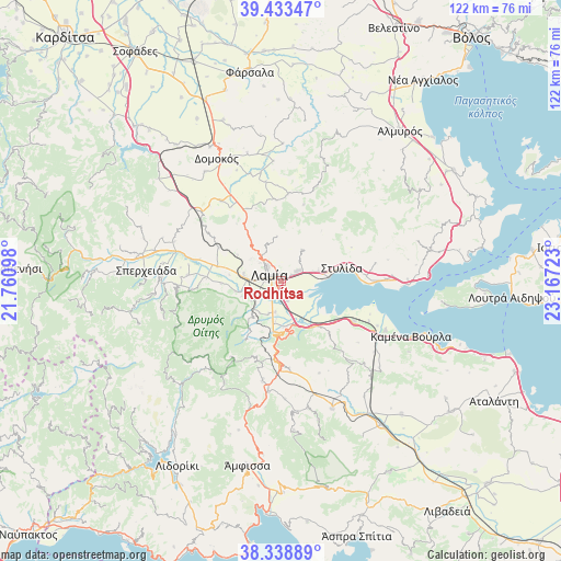
Rodhítsa GPS coordinates[2]
38° 53' 17.844" North, 22° 27' 50.76" East
| Map corner | latitude | longitude |
|---|---|---|
| Upper-left | 39.43347°, | 21.76098° |
| Center: | 38.88829°, | 22.4641° |
| Lower-right: | 38.33889°, | 23.16723° |
| Map W x H: | 121.7×121.7 km | = 75.6×75.6mi |
| max Lat: | 41.72048° ⇑56.1% North |
| Rodhítsa: | 38.88829° |
| min Lat: | ⇓43.9% South 34.8346° |
| min Long | Rodhítsa | max Long |
| 19.40494° | 22.4641° | 29.59361° |
| W 39%⇐ | ⇒61% E |
Elevation
Elevation of Rodhítsa is 25 m = 82 ft, and this is 143.9 m = 472 ft below average elevation for this country.
| Max E: |
1439 m = 4721 ft | 74.1% |
| Avg. | 168.9 m = 554 ft | |
| Rodhítsa | 25 m = 82 ft | |
Min E: |
0 m = 0 ft | 25.9% |
See also: Greece elevation on elevation.city.
Geographical zone
Rodhítsa is located in North temperate zone (between Tropic of Cancer and the Arctic Circle). Distance of this Northern Tropic circle is 1718.1 km =1067.6 mi to South.| Distance of | km | miles | from Rodhítsa |
|---|---|---|---|
| North Pole | 5683.1 | 3531.3 | to North |
| Arctic Circle | 3077.2 | 1912.1 | to North |
| Tropic Cancer | 1718.1 | 1067.6 | to South |
| Equator | 4324 | 2686.8 | to South |


Nearby cities:
15 places around Rodhítsa: (largest is in red/bold)
• Agía Paraskeví Lamiéon
2.7 km =1.7 mi,  57°
57°
• Akhinós
22.6 km =14 mi,  88°
88°
• Anthíli
4.5 km =2.8 mi,  163°
163°
• Anávra
21.8 km =13.5 mi,  20°
20°
• Frantzís
7.9 km =4.9 mi,  236°
236°
• Karavómilos
21.1 km =13.1 mi, 89°
• Kompotádes
10.3 km =6.4 mi,  257°
257°
• Lamía
3 km =1.9 mi,  296°
296°
• Lianokládhion
14.3 km =8.9 mi,  282°
282°
• Megáli Vrísi
1.1 km =0.7 mi, 56°
• Mexiátai
13 km =8.1 mi,  267°
267°
• Moskhokhórion
6.8 km =4.2 mi,  191°
191°
• Mólos
18 km =11.2 mi,  119°
119°
• Stavrós
8.1 km =5 mi, 276°
• Stylída
13.6 km =8.5 mi,  76°
76°
Sources, notices
• [Note1] Compared only with cities in Greece existing in our database
• [Src1] Map data: © OpenStreetMap contributors (CC-BY-SA)
• [Src2] Other city data from geonames.org with taken over terms of usage.
• [Src3] Geographical zone / Annual Mean Temperature by Robert A. Rohde @ Wikipedia
