Anávra geodata
Anávra (Thessaly) is a populated place; located in Greece in Europe/Athens (GMT+3) time zone. With population of 584 people, there are 1612 cities with bigger population in this country. Compared to other cities in Greece, 53.5% of cities are located further ↑North; 58.3% of cities are located further →East and 97% of cities have lower elevation than Anávra. Note1


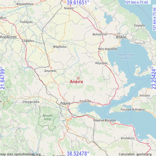
Anávra GPS coordinates[2]
39° 4' 21.936" North, 22° 33' 3.996" East
| Map corner | latitude | longitude |
|---|---|---|
| Upper-left | 39.61651°, | 21.84799° |
| Center: | 39.07276°, | 22.55111° |
| Lower-right: | 38.52478°, | 23.25424° |
| Map W x H: | 121.4×121.4 km | = 75.4×75.4mi |
| max Lat: | 41.72048° ⇑53.5% North |
| Anávra: | 39.07276° |
| min Lat: | ⇓46.5% South 34.8346° |
| min Long | Anávra | max Long |
| 19.40494° | 22.55111° | 29.59361° |
| W 41.7%⇐ | ⇒58.3% E |
Elevation
Elevation of Anávra is 777 m = 2549 ft, and this is 608.1 m = 1995 ft above average elevation for this country.
| Max E: |
1439 m = 4721 ft | 3% |
| Anávra | 777 m 2549 ft | |
| Avg. | 168.9 m = 554 ft | |
Min E: |
0 m = 0 ft | 97% |
See also: Greece elevation on elevation.city.
Geographical zone
Anávra is located in North temperate zone (between Tropic of Cancer and the Arctic Circle). Distance of this Northern Tropic circle is 1738.6 km =1080.3 mi to South.| Distance of | km | miles | from Anávra |
|---|---|---|---|
| North Pole | 5662.6 | 3518.6 | to North |
| Arctic Circle | 3056.7 | 1899.3 | to North |
| Tropic Cancer | 1738.6 | 1080.3 | to South |
| Equator | 4344.5 | 2699.5 | to South |


Nearby cities:
15 places around Anávra: (largest is in red/bold)
• Agía Paraskeví Lamiéon
19.8 km =12.3 mi,  195°
195°
• Akhinós
25 km =15.5 mi,  143°
143°
• Almyrós
21.7 km =13.5 mi,  55°
55°
• Anthíli
25.5 km =15.8 mi,  194°
194°
• Domokós
22.5 km =14 mi,  285°
285°
• Evxinoúpolis
20.3 km =12.6 mi,  52°
52°
• Karavómilos
24.5 km =15.2 mi,  146°
146°
• Lamía
21.7 km =13.5 mi,  207°
207°
• Lianokládhion
27.6 km =17.1 mi,  230°
230°
• Megáli Vrísi
20.9 km =13 mi, 198°
• Néos Plátanos
23.2 km =14.4 mi, 64°
• Omvriakí
24.4 km =15.2 mi,  277°
277°
• Rodhítsa
21.8 km =13.5 mi, 200°
• Stavrós
25 km =15.5 mi,  218°
218°
• Stylída
18.3 km =11.4 mi,  161°
161°
Sources, notices
• [Note1] Compared only with cities in Greece existing in our database
• [Src1] Map data: © OpenStreetMap contributors (CC-BY-SA)
• [Src2] Other city data from geonames.org with taken over terms of usage.
• [Src3] Geographical zone / Annual Mean Temperature by Robert A. Rohde @ Wikipedia
