Christoúpoli geodata
Christoúpoli (Attica) is a populated place; located in Greece in Europe/Athens (GMT+3) time zone. With population of 518 people, there are 1770 cities with bigger population in this country. Compared to other cities in Greece, 74.5% of cities are located further ↑North; 76.6% of cities are located further ←West and 64.7% of cities have lower elevation than Christoúpoli. Note1
Administrative division(s):
- Level 1: Attica
- Level 2: Nomarchía Anatolikís Attikís
- Level 3: Dimos Spata-Artemida


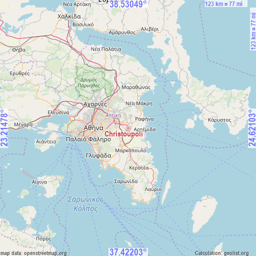
Christoúpoli GPS coordinates[2]
37° 58' 42.06" North, 23° 55' 4.44" East
| Map corner | latitude | longitude |
|---|---|---|
| Upper-left | 38.53049°, | 23.21478° |
| Center: | 37.97835°, | 23.9179° |
| Lower-right: | 37.42203°, | 24.62103° |
| Map W x H: | 123.2×123.2 km | = 76.6×76.6mi |
| max Lat: | 41.72048° ⇑74.5% North |
| Christoúpoli: | 37.97835° |
| min Lat: | ⇓25.5% South 34.8346° |
| min Long | Christoúpoli | max Long |
| 19.40494° | 23.9179° | 29.59361° |
| W 76.6%⇐ | ⇒23.4% E |
Elevation
Elevation of Christoúpoli is 139 m = 456 ft, and this is 29.9 m = 98 ft below average elevation for this country.
| Max E: |
1439 m = 4721 ft | 35.3% |
| Avg. | 168.9 m = 554 ft | |
| Christoúpoli | 139 m = 456 ft | |
Min E: |
0 m = 0 ft | 64.7% |
See also: Greece elevation on elevation.city.
Geographical zone
Christoúpoli is located in North temperate zone (between Tropic of Cancer and the Arctic Circle). Distance of this Northern Tropic circle is 1616.9 km =1004.7 mi to South.| Distance of | km | miles | from Christoúpoli |
|---|---|---|---|
| North Pole | 5784.3 | 3594.2 | to North |
| Arctic Circle | 3178.4 | 1975 | to North |
| Tropic Cancer | 1616.9 | 1004.7 | to South |
| Equator | 4222.8 | 2623.9 | to South |


Nearby cities:
15 places around Christoúpoli: (largest is in red/bold)
• Agia Kyriakií Spáton
5.5 km =3.4 mi,  72°
72°
• Anthoúsa
6.4 km =4 mi,  325°
325°
• Argithéa
2.9 km =1.8 mi,  262°
262°
• Artémida
7 km =4.3 mi,  100°
100°
• Dhráfi
5.1 km =3.2 mi,  350°
350°
• Dióni
5.2 km =3.2 mi,  14°
14°
• Gérakas
7.2 km =4.5 mi,  313°
313°
• Kallitechnoúpoli
6.4 km =4 mi,  33°
33°
• Karellás
6.7 km =4.2 mi,  223°
223°
• Leondárion
5.6 km =3.5 mi,  279°
279°
• Neápoli Spáton
5.5 km =3.4 mi, 104°
• Paianía
6.1 km =3.8 mi,  245°
245°
• Pallíni
4.3 km =2.7 mi, 314°
• Pikérmi
3.3 km =2.1 mi,  37°
37°
• Spáta
1.9 km =1.2 mi,  187°
187°
Sources, notices
• [Note1] Compared only with cities in Greece existing in our database
• [Src1] Map data: © OpenStreetMap contributors (CC-BY-SA)
• [Src2] Other city data from geonames.org with taken over terms of usage.
• [Src3] Geographical zone / Annual Mean Temperature by Robert A. Rohde @ Wikipedia
