Argithéa geodata
Argithéa (Attica) is a populated place; located in Greece in Europe/Athens (GMT+3) time zone. With population of 1,024 people, there are 988 cities with bigger population in this country. Compared to other cities in Greece, 74.8% of cities are located further ↑North; 76% of cities are located further ←West and 76.2% of cities have lower elevation than Argithéa. Note1
Administrative division(s):
- Level 1: Attica
- Level 2: Nomarchía Anatolikís Attikís
- Level 3: Dimos Paiania


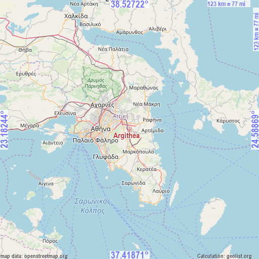
Argithéa GPS coordinates[2]
37° 58' 30.216" North, 23° 53' 8.016" East
| Map corner | latitude | longitude |
|---|---|---|
| Upper-left | 38.52722°, | 23.18244° |
| Center: | 37.97506°, | 23.88556° |
| Lower-right: | 37.41871°, | 24.58869° |
| Map W x H: | 123.3×123.3 km | = 76.6×76.6mi |
| max Lat: | 41.72048° ⇑74.8% North |
| Argithéa: | 37.97506° |
| min Lat: | ⇓25.2% South 34.8346° |
| min Long | Argithéa | max Long |
| 19.40494° | 23.88556° | 29.59361° |
| W 76%⇐ | ⇒24% E |
Elevation
Elevation of Argithéa is 224 m = 735 ft, and this is 55.1 m = 181 ft above average elevation for this country.
| Max E: |
1439 m = 4721 ft | 23.8% |
| Argithéa | 224 m 735 ft | |
| Avg. | 168.9 m = 554 ft | |
Min E: |
0 m = 0 ft | 76.2% |
See also: Greece elevation on elevation.city.
Geographical zone
Argithéa is located in North temperate zone (between Tropic of Cancer and the Arctic Circle). Distance of this Northern Tropic circle is 1616.5 km =1004.4 mi to South.| Distance of | km | miles | from Argithéa |
|---|---|---|---|
| North Pole | 5784.6 | 3594.4 | to North |
| Arctic Circle | 3178.7 | 1975.2 | to North |
| Tropic Cancer | 1616.5 | 1004.4 | to South |
| Equator | 4222.4 | 2623.7 | to South |


Nearby cities:
15 places around Argithéa: (largest is in red/bold)
• Agía Paraskeví
6.5 km =4 mi,  315°
315°
• Anthoúsa
5.7 km =3.5 mi,  351°
351°
• Cholargós
8 km =5 mi,  290°
290°
• Christoúpoli
2.9 km =1.8 mi,  82°
82°
• Dhráfi
5.8 km =3.6 mi,  19°
19°
• Dióni
6.8 km =4.2 mi,  37°
37°
• Gérakas
5.8 km =3.6 mi,  335°
335°
• Karellás
4.9 km =3 mi,  201°
201°
• Leondárion
3 km =1.9 mi,  296°
296°
• Neápoli Spáton
8.2 km =5.1 mi,  97°
97°
• Paianía
3.5 km =2.2 mi,  231°
231°
• Pallíni
3.4 km =2.1 mi,  356°
356°
• Papágou
8.2 km =5.1 mi,  278°
278°
• Pikérmi
5.7 km =3.5 mi,  58°
58°
• Spáta
3 km =1.9 mi,  119°
119°
Sources, notices
• [Note1] Compared only with cities in Greece existing in our database
• [Src1] Map data: © OpenStreetMap contributors (CC-BY-SA)
• [Src2] Other city data from geonames.org with taken over terms of usage.
• [Src3] Geographical zone / Annual Mean Temperature by Robert A. Rohde @ Wikipedia
